IMAGES TAKEN NEAR TO
Beagles Close, KIDLINGTON, OX5 2QJ
Introduction
This page details the photographs taken nearby to Beagles Close, OX5 2QJ by members of the Geograph project.
The Geograph project started in 2005 with the aim of publishing, organising and preserving representative images for every square kilometre of Great Britain, Ireland and the Isle of Man.

There are currently over 7.5m images from over14,400 individuals and you can help contribute to the project by visiting https://www.geograph.org.uk
Image Map
Images are licensed for reuse under creativecommons.org/licenses/by-sa/2.0
Notes
- Clicking on the map will re-center to the selected point.
- The higher the marker number, the further away the image location is from the centre of the postcode.
Image Listing (17 Images Found)
Images are licensed for reuse under creativecommons.org/licenses/by-sa/2.0
Image
Details
Distance
4
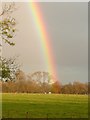
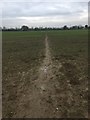
Field of cows with rainbow
Pasture land off Water Eaton Lane, Gosford
Image: © Ruth French
Taken: 7 Nov 2008
0.10 miles
5
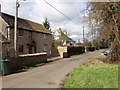
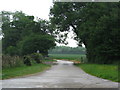
Water Eaton Lane, Gosford
Just outside the built up area of Kidlington, this lane has just a few houses along it.
Image: © David Hawgood
Taken: 2 Mar 2007
0.12 miles
6
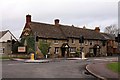
The Kings Arms on Bicester Road
The Kings Arms is part of the Harvester chain.
Image: © Steve Daniels
Taken: 25 Jan 2012
0.12 miles
7
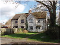
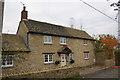
Houses in Gosford
In Water Eaton Lane.
Image: © David Hawgood
Taken: 2 Mar 2007
0.13 miles