IMAGES TAKEN NEAR TO
Cromwell Way, KIDLINGTON, OX5 2LN
Introduction
This page details the photographs taken nearby to Cromwell Way, OX5 2LN by members of the Geograph project.
The Geograph project started in 2005 with the aim of publishing, organising and preserving representative images for every square kilometre of Great Britain, Ireland and the Isle of Man.

There are currently over 7.5m images from over14,400 individuals and you can help contribute to the project by visiting https://www.geograph.org.uk
Image Map
Images are licensed for reuse under creativecommons.org/licenses/by-sa/2.0
Notes
- Clicking on the map will re-center to the selected point.
- The higher the marker number, the further away the image location is from the centre of the postcode.
Image Listing (10 Images Found)
Images are licensed for reuse under creativecommons.org/licenses/by-sa/2.0
Image
Details
Distance
3
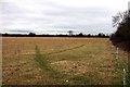
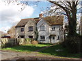
Water Eaton Lane, Gosford
Just outside the built up area of Kidlington, this lane has just a few houses along it.
Image: © David Hawgood
Taken: 2 Mar 2007
0.20 miles
4
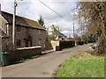
Houses in Gosford
In Water Eaton Lane.
Image: © David Hawgood
Taken: 2 Mar 2007
0.21 miles
6
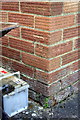
Benchmark on #42 Bicester Road
Ordnance Survey cut mark benchmark described on the Bench Mark Database at http://www.bench-marks.org.uk/bm29214
Image: © Roger Templeman
Taken: 28 Nov 2012
0.22 miles
7

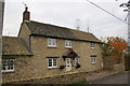
#42 Bicester Road
There is an OS benchmark Image on the front left corner of the house
Image: © Roger Templeman
Taken: 28 Nov 2012
0.22 miles
9
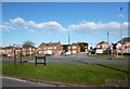
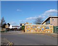
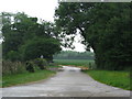
Opposite Police HQ
Just off Oxford Road is the Thames Valley Police Headquarters. That's their mast.
Image: © Des Blenkinsopp
Taken: 17 Feb 2013
0.24 miles