IMAGES TAKEN NEAR TO
Field Close, KIDLINGTON, OX5 2HH
Introduction
This page details the photographs taken nearby to Field Close, OX5 2HH by members of the Geograph project.
The Geograph project started in 2005 with the aim of publishing, organising and preserving representative images for every square kilometre of Great Britain, Ireland and the Isle of Man.

There are currently over 7.5m images from over14,400 individuals and you can help contribute to the project by visiting https://www.geograph.org.uk
Image Map
Images are licensed for reuse under creativecommons.org/licenses/by-sa/2.0
Notes
- Clicking on the map will re-center to the selected point.
- The higher the marker number, the further away the image location is from the centre of the postcode.
Image Listing (9 Images Found)
Images are licensed for reuse under creativecommons.org/licenses/by-sa/2.0
Image
Details
Distance

2
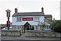
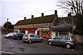
Six Bells (1), 70 Mill Street, Kidlington
A traditional pub in the older part of the village, with a beer garden. Two pool tables, Aunt Sally and food are also available. The present building dates from between 1818 and 1831, by which time it was definitely in use as a pub. One theory is that it was the successor to a beer house opposite at 61 Mill Street, known as The Harrow. That establishment apparently had a licence dating back to 1535, but whether this believed connection is correct is not known.
Image
Image: © P L Chadwick
Taken: 20 Nov 2011
0.17 miles
3

Six Bells (2) - sign, 70 Mill Street, Kidlington
The local parish church of St. Mary the Virgin has a peel of eight bells, so presumably this pub's name is not connected with it.
Image
Image: © P L Chadwick
Taken: 20 Nov 2011
0.17 miles
5
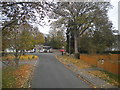
North end of Evans Lane, Kidlington
Looking towards the junction with Mill Street.
Image: © Richard Vince
Taken: 8 Nov 2016
0.19 miles
6

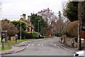
Public Footpath in Kidlington cuts across Front Garden
The village green has been built over, but the rights of way have been preserved, here cutting across a front garden.
Image: © Sarah Charlesworth
Taken: 15 Sep 2008
0.19 miles
9
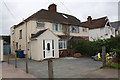
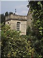
Nos. 107 and 109 Oxford Road
There was (shown on 1982 Map) an Ordnance Survey benchmark on the front, left hand corner, of the left hand house, #107. The mark appears to have been lost to the porch extension.
Image: © Roger Templeman
Taken: 22 Apr 2016
0.25 miles