IMAGES TAKEN NEAR TO
The Closes, KIDLINGTON, OX5 2DP
Introduction
This page details the photographs taken nearby to The Closes, OX5 2DP by members of the Geograph project.
The Geograph project started in 2005 with the aim of publishing, organising and preserving representative images for every square kilometre of Great Britain, Ireland and the Isle of Man.

There are currently over 7.5m images from over14,400 individuals and you can help contribute to the project by visiting https://www.geograph.org.uk
Image Map
Images are licensed for reuse under creativecommons.org/licenses/by-sa/2.0
Notes
- Clicking on the map will re-center to the selected point.
- The higher the marker number, the further away the image location is from the centre of the postcode.
Image Listing (49 Images Found)
Images are licensed for reuse under creativecommons.org/licenses/by-sa/2.0
Image
Details
Distance
1
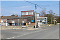
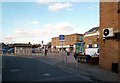
High Street, Kidlington
The High Street travelling east from the main shopping area. This, the old part of Kidlington has considerably more charm than the modern housing estates that have sprung up on the outskirts of the village.
Image: © Alan Hunt
Taken: 13 Mar 2016
0.03 miles
2
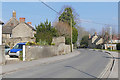
High Street, Kidlington
Looking east along the High Street as it leaves the village centre with Home close on the left. Kidlington is still designated a village although it meets all the criteria for a town. The local population voted by 98% to keep it a village in a recent poll.
Image: © Alan Hunt
Taken: 13 Mar 2016
0.04 miles
3
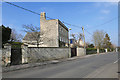
The High Street, Kidlington
One of the older houses, possibly Georgian, on the High Street.
Image: © Alan Hunt
Taken: 13 Mar 2016
0.05 miles
4
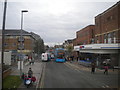
High Street, Kidlington
Looking towards the centre of the village, with a Scania N230/Alexander Dennis Enviro 400 of the Oxford Bus Company on route 2 to Oxford city centre.
Image: © Richard Vince
Taken: 8 Nov 2016
0.08 miles
5
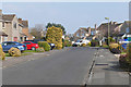
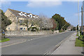
Benmead Road, Kidlington
A residential road in the modern housing estates that have sprung up around the original village.
Image: © Alan Hunt
Taken: 13 Mar 2016
0.10 miles
7
Kidlington Baptist Church
The baptist Church at the eastern end of the High Street.
Image: © Alan Hunt
Taken: 13 Mar 2016
0.14 miles
8
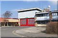
Kidlington fire station
The fire station on Sterling Road Approach near the centre of Kidlington.
Image: © Alan Hunt
Taken: 13 Mar 2016
0.14 miles
10
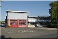
Kidlington fire station
Kidlington fire station, Sterling Road, Kidlington, Oxfordshire
Image: © Kevin Hale
Taken: 5 Oct 2007
0.14 miles