IMAGES TAKEN NEAR TO
Banbury Road, KIDLINGTON, OX5 2BU
Introduction
This page details the photographs taken nearby to Banbury Road, OX5 2BU by members of the Geograph project.
The Geograph project started in 2005 with the aim of publishing, organising and preserving representative images for every square kilometre of Great Britain, Ireland and the Isle of Man.

There are currently over 7.5m images from over14,400 individuals and you can help contribute to the project by visiting https://www.geograph.org.uk
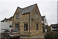
Image Map
Images are licensed for reuse under creativecommons.org/licenses/by-sa/2.0
Notes
- Clicking on the map will re-center to the selected point.
- The higher the marker number, the further away the image location is from the centre of the postcode.
Image Listing (40 Images Found)
Images are licensed for reuse under creativecommons.org/licenses/by-sa/2.0
Image
Details
Distance
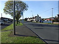
2
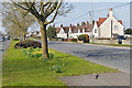
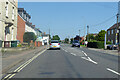
Banbury Road, Kidlington
Looking north along the Banbury Road as it leaves Kidlington.
Image: © Alan Hunt
Taken: 13 Mar 2016
0.03 miles
4
Banbury Road, Kidlington
Looking north along the A4260 Banbury Road. There has been considerable ribbon development along the A4260 extending the area of the village well beyond its original size.
Image: © Alan Hunt
Taken: 13 Mar 2016
0.06 miles
5
Banbury Road
This photograph taken from a viewpoint close to one of Alan's photographs Image is submitted in memory of the late Alan Hunt whose funeral is due to be held later today. I never met my fellow contributor but we briefly exchanged email messages last year about a photograph taken nearbyImage
Image: © Dennis Turner
Taken: 4 May 2016
0.06 miles
6
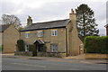
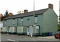
#37 Banbury Road
There is an OS benchmark Image on the near corner, right hand face, of the house, left of the black downpipe at junction with stone wall
Image: © Roger Templeman
Taken: 9 Nov 2012
0.08 miles
7
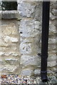
Benchmark on #37 Banbury Road
Ordnance Survey cut mark benchmark described on the Bench Mark Database at www.bench-marks.org.uk/bm29212
Image: © Roger Templeman
Taken: 9 Nov 2012
0.08 miles
8
Wise Avenue, Kidlington
A residential road off the Benmead Road in Kidlington
Image: © Alan Hunt
Taken: 13 Mar 2016
0.09 miles
9
A4260 Banbury Road, Kidlington
Towards Banbury.
Image: © Robin Webster
Taken: 18 Jul 2021
0.11 miles
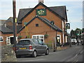
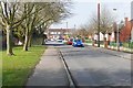
10
Houses on Banbury Road
Thankfully these have returned to a more sober appearance than in this 2008 view http://www.geograph.org.uk/photo/988103
Image: © Alan Murray-Rust
Taken: 20 Oct 2015
0.11 miles