IMAGES TAKEN NEAR TO
The Paddocks, KIDLINGTON, OX5 1TE
Introduction
This page details the photographs taken nearby to The Paddocks, OX5 1TE by members of the Geograph project.
The Geograph project started in 2005 with the aim of publishing, organising and preserving representative images for every square kilometre of Great Britain, Ireland and the Isle of Man.

There are currently over 7.5m images from over14,400 individuals and you can help contribute to the project by visiting https://www.geograph.org.uk
Image Map
Images are licensed for reuse under creativecommons.org/licenses/by-sa/2.0
Notes
- Clicking on the map will re-center to the selected point.
- The higher the marker number, the further away the image location is from the centre of the postcode.
Image Listing (23 Images Found)
Images are licensed for reuse under creativecommons.org/licenses/by-sa/2.0
Image
Details
Distance
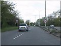
2
National Cycle Network Route 5
Beside Woodstock Road (A44).
Image: © JThomas
Taken: 15 Apr 2023
0.17 miles
4
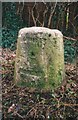
Milestone with benchmark beside Woodstock Road
Ordnance Survey cut mark benchmark described on the Bench Mark Database at http://www.bench-marks.org.uk/bm46247
Image: © Roger Templeman
Taken: 30 Oct 2014
0.18 miles
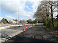
6
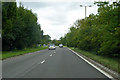
A44 Woodstock Road
Here a dual carriageway.
Image: © Robin Webster
Taken: 11 Aug 2019
0.18 miles
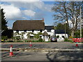
7
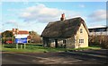
A Relic of Old Yarnton
This old thatched cottage sits incongruously on a patch of grass between a large electricity depot behind and suburban housing opposite.
It seems in quite good repair, but is empty.
If it was somewhere else it would no doubt be a des. res. but here it's just a bit sad.
Image: © Des Blenkinsopp
Taken: 7 Dec 2014
0.18 miles
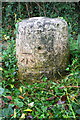
8
Old Milestone by the A44, Woodstock Road, Yarnton
Stokenchurch pillar by the A44, in parish of Yarnton (Cherwell District), Woodstock Road; just before slip road to garage at The Garth, near last large tree, well back from the cycle track, on edge of concrete lined culvert for stream.
Inscription once read:-
(Woodstock)
(3)
(Oxford)
(4)
Carved benchmark on face.
Oxfordshire HER.
HER Number: 10045 https://www.heritagegateway.org.uk/Gateway/Results_Single.aspx?uid=MOX3969&resourceID=1033
Surveyed
Milestone Society National ID: OX_lw59
Image: © Milestone Society
Taken: Unknown
0.18 miles
9
Milestone beside the A44, Woodstock Road
There is an OS benchmark Image on the front face of the milestone
Image: © Roger Templeman
Taken: 30 Oct 2014
0.19 miles
