IMAGES TAKEN NEAR TO
Woodstock Road West, KIDLINGTON, OX5 1RJ
Introduction
This page details the photographs taken nearby to Woodstock Road West, OX5 1RJ by members of the Geograph project.
The Geograph project started in 2005 with the aim of publishing, organising and preserving representative images for every square kilometre of Great Britain, Ireland and the Isle of Man.

There are currently over 7.5m images from over14,400 individuals and you can help contribute to the project by visiting https://www.geograph.org.uk
Image Map
Images are licensed for reuse under creativecommons.org/licenses/by-sa/2.0
Notes
- Clicking on the map will re-center to the selected point.
- The higher the marker number, the further away the image location is from the centre of the postcode.
Image Listing (44 Images Found)
Images are licensed for reuse under creativecommons.org/licenses/by-sa/2.0
Image
Details
Distance
3
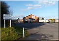
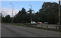
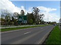
Begbroke Village Hall
Begbroke village name is nothing to do with being short of cash. "Bechebroc" in The Domesday Book, meaning Becca's Brook. (Oxford Dictionary of Place Names)
Image: © Des Blenkinsopp
Taken: 17 Feb 2013
0.10 miles