IMAGES TAKEN NEAR TO
Woodstock Road, KIDLINGTON, OX5 1PU
Introduction
This page details the photographs taken nearby to Woodstock Road, OX5 1PU by members of the Geograph project.
The Geograph project started in 2005 with the aim of publishing, organising and preserving representative images for every square kilometre of Great Britain, Ireland and the Isle of Man.

There are currently over 7.5m images from over14,400 individuals and you can help contribute to the project by visiting https://www.geograph.org.uk
Image Map
Images are licensed for reuse under creativecommons.org/licenses/by-sa/2.0
Notes
- Clicking on the map will re-center to the selected point.
- The higher the marker number, the further away the image location is from the centre of the postcode.
Image Listing (14 Images Found)
Images are licensed for reuse under creativecommons.org/licenses/by-sa/2.0
Image
Details
Distance
1
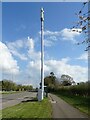
Phone mast beside National Cycle Network Route 5
Image: © JThomas
Taken: 15 Apr 2023
0.03 miles
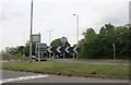
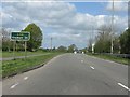
3

Sandy Lane roundabout on A44 (Woodstock Road)
Image: © Roger Templeman
Taken: 28 Nov 2012
0.04 miles
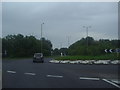
5
A44 approaching North Yarnton roundabout
Image: © Peter Whatley
Taken: 12 Apr 2011
0.10 miles
6
A44 - route confirmatory sign north of Yarnton
Image: © Peter Whatley
Taken: 12 Apr 2011
0.11 miles


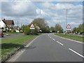
9
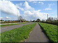
National Cycle Network Route 5 towards Oxford
Beside Woodstock Road (A44).
Image: © JThomas
Taken: 15 Apr 2023
0.15 miles
10
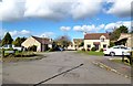
The Spears, Yarnton
A strangely named street at the north end of Yarnton.
Image: © Des Blenkinsopp
Taken: 23 Oct 2013
0.17 miles