IMAGES TAKEN NEAR TO
Woodstock Road, KIDLINGTON, OX5 1PH
Introduction
This page details the photographs taken nearby to Woodstock Road, OX5 1PH by members of the Geograph project.
The Geograph project started in 2005 with the aim of publishing, organising and preserving representative images for every square kilometre of Great Britain, Ireland and the Isle of Man.

There are currently over 7.5m images from over14,400 individuals and you can help contribute to the project by visiting https://www.geograph.org.uk
Image Map
Images are licensed for reuse under creativecommons.org/licenses/by-sa/2.0
Notes
- Clicking on the map will re-center to the selected point.
- The higher the marker number, the further away the image location is from the centre of the postcode.
Image Listing (40 Images Found)
Images are licensed for reuse under creativecommons.org/licenses/by-sa/2.0
Image
Details
Distance
1
'Bridge End' on NW side of the A44
The house replaces a former building which had an Ordnance Survey benchmark described on the Bench Mark Database at http://www.bench-marks.org.uk/bm46242
Image: © Roger Templeman
Taken: 22 Mar 2016
0.01 miles
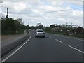
3
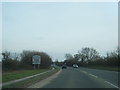
A44 Woodstock Road
Towards Woodstock from Oxford.
Image: © Robin Webster
Taken: 11 Aug 2019
0.04 miles
5
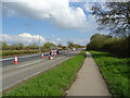
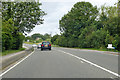
National Cycle Network Route 5 towards Oxford
Beside Woodstock Road (A44).
Image: © JThomas
Taken: 15 Apr 2023
0.07 miles
6
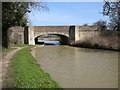
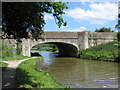
Oxford Canal bridge 230
This bridge carries the A44 across the canal. Why this short (less than one mile) stretch of the A44 has not been dualled will remain a mystery for years.
Image: © David Purchase
Taken: 14 Mar 2016
0.10 miles
7
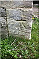
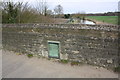
Benchmark on King's Bridge (canalside)
Ordnance Survey cut mark benchmark described on the Bench Mark Database at http://www.bench-marks.org.uk/bm27018
Image: © Roger Templeman
Taken: 22 Mar 2016
0.11 miles
8
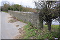
NE parapet of King's Bridge (A44 over Oxford Canal)
There is an OS benchmark Image on the near end of the parapet, road face.
Image: © Roger Templeman
Taken: 22 Mar 2016
0.11 miles
9
Oxford Canal seen over NE parapet of King's Bridge
The plaque records the rebuilding of the bridge in 1936. See http://www.bench-marks.org.uk/bm19999 for information about an Ordnance Survey benchmark on the earlier bridge
Image: © Roger Templeman
Taken: 22 Mar 2016
0.11 miles