IMAGES TAKEN NEAR TO
Pixey Close, KIDLINGTON, OX5 1FY
Introduction
This page details the photographs taken nearby to Pixey Close, OX5 1FY by members of the Geograph project.
The Geograph project started in 2005 with the aim of publishing, organising and preserving representative images for every square kilometre of Great Britain, Ireland and the Isle of Man.

There are currently over 7.5m images from over14,400 individuals and you can help contribute to the project by visiting https://www.geograph.org.uk
Image Map
Images are licensed for reuse under creativecommons.org/licenses/by-sa/2.0
Notes
- Clicking on the map will re-center to the selected point.
- The higher the marker number, the further away the image location is from the centre of the postcode.
Image Listing (74 Images Found)
Images are licensed for reuse under creativecommons.org/licenses/by-sa/2.0
Image
Details
Distance
2
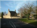
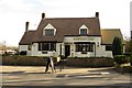
Jacksons Farmhouse, Cassington Road
There is an OS benchmark Image on the right hand front corner of the farmhouse at its junction with the stone wall
Image: © Roger Templeman
Taken: 30 Oct 2014
0.10 miles
3
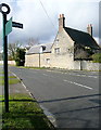
Yarnton signpost
At the junction of Cassington Road with Rutten Lane. This must be a desirable area to live, because it is an attractive village but on a regular bus route to Oxford. We are walking there, on Shakespeare's Way.
Image: © Graham Horn
Taken: 16 Mar 2013
0.10 miles
4
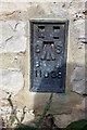
Benchmark on Jacksons Farmhouse
Ordnance Survey flush bracket (serial number 11038) benchmark described on the Bench Mark Database at http://www.bench-marks.org.uk/bm19490
Image: © Roger Templeman
Taken: 30 Oct 2014
0.10 miles
5

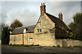
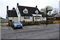
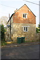
At the junction of Church Close and Park Close
Shakespeare's Way passes this house. I think it is rather attractive, but would struggle to date it. What unusual windows.
Image: © Graham Horn
Taken: 16 Mar 2013
0.10 miles
7
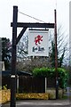
The Red Lion (2) - sign, 127 Cassington Road, Yarnton, Oxon
The Red Lion remains the most common name given to public houses. The name derives from King James VI of Scotland, who inherited the English throne in 1603, on the death of Queen Elizabeth I. He became King James I of England, and to reinforce his authority to rule, he decreed that all public buildings (including taverns) must display a heraldic red lion in a prominent position. This resulted in many pubs acquiring the Red Lion name. This particular Red Lion pub probably wasn't around in the 17th century, but the tradition of giving this name to pubs seems to have carried on for a long time. According to The Inn Sign Society's website, there are thought to be about 600 Red Lion pubs.
Image
Image: © P L Chadwick
Taken: 11 Mar 2024
0.16 miles
8
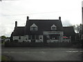
The Red Lion (1), 127 Cassington Road, Yarnton, Oxon
Local public house run by Oak Taverns.
Image
Image: © P L Chadwick
Taken: 11 Mar 2024
0.16 miles
10
Nos. 188 and 190 Cassington Road
There is an OS benchmark Image on the road face of the house on a corner stone next to the wooden gate
Image: © Roger Templeman
Taken: 30 Oct 2014
0.21 miles