IMAGES TAKEN NEAR TO
Morton Close, KIDLINGTON, OX5 1BU
Introduction
This page details the photographs taken nearby to Morton Close, OX5 1BU by members of the Geograph project.
The Geograph project started in 2005 with the aim of publishing, organising and preserving representative images for every square kilometre of Great Britain, Ireland and the Isle of Man.

There are currently over 7.5m images from over14,400 individuals and you can help contribute to the project by visiting https://www.geograph.org.uk
Image Map
Images are licensed for reuse under creativecommons.org/licenses/by-sa/2.0
Notes
- Clicking on the map will re-center to the selected point.
- The higher the marker number, the further away the image location is from the centre of the postcode.
Image Listing (30 Images Found)
Images are licensed for reuse under creativecommons.org/licenses/by-sa/2.0
Image
Details
Distance
1
Yarnton Court, Yarnton Road
There is an OS benchmark Image on the left side of the house just through the wooden garage.
Image: © Roger Templeman
Taken: 28 Nov 2012
0.08 miles
2
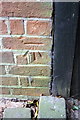
Benchmark on Yarnton Court (#26 Yarnton Road)
Ordnance Survey cut mark benchmark described on the Bench Mark Database at http://www.bench-marks.org.uk/bm29216
Image: © Roger Templeman
Taken: 28 Nov 2012
0.08 miles
3
Kidlington Telephone Exchange, Oxon
Located at 12 Yarnton Road OX5 1AT, this TE dates from the GPO era and serves Kidlington plus Begbroke, Gosford, Islip, Thrupp and Yarnton nearby. BT warning notices and a yellow grit salt bin can be seen in this photo. The numbering ranges of this TE are (01865) 37xxxx and 84xxxx, the (01865) referring to the Oxford group of TEs.
Image: © David Hillas
Taken: 8 Oct 2016
0.09 miles
4
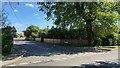
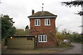
Junction of Yarnton Road and Morton Avenue, Kidlington
Image: © Sean Pearce
Taken: 26 Apr 2020
0.09 miles
5
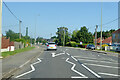
A4260 Oxford Road, Kidlington
Heading north towards the centre of Kidlington.
Image: © Robin Webster
Taken: 18 Jul 2021
0.11 miles
6
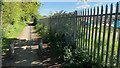
Footpath at northeastern edge of allotment gardens, Kidlington
Image: © Sean Pearce
Taken: 26 Apr 2020
0.13 miles
7
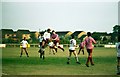
Kidlington football ground on Yarnton Road
Image: © Steve Daniels
Taken: 2 Aug 1990
0.14 miles
8
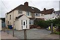
Nos. 107 and 109 Oxford Road
There was (shown on 1982 Map) an Ordnance Survey benchmark on the front, left hand corner, of the left hand house, #107. The mark appears to have been lost to the porch extension.
Image: © Roger Templeman
Taken: 22 Apr 2016
0.14 miles
9
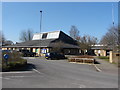
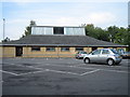
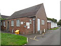
Exeter Hall. Kidlington
The Exeter Hall, Kidlington has been the site of the Oxford Mineral Shows for a number of years.
Image: © Alan Hunt
Taken: 7 Mar 2010
0.15 miles