IMAGES TAKEN NEAR TO
Greenfield, WATLINGTON, OX49 5HJ
Introduction
This page details the photographs taken nearby to Greenfield, OX49 5HJ by members of the Geograph project.
The Geograph project started in 2005 with the aim of publishing, organising and preserving representative images for every square kilometre of Great Britain, Ireland and the Isle of Man.

There are currently over 7.5m images from over14,400 individuals and you can help contribute to the project by visiting https://www.geograph.org.uk
Image Map
Images are licensed for reuse under creativecommons.org/licenses/by-sa/2.0
Notes
- Clicking on the map will re-center to the selected point.
- The higher the marker number, the further away the image location is from the centre of the postcode.
Image Listing (6 Images Found)
Images are licensed for reuse under creativecommons.org/licenses/by-sa/2.0
Image
Details
Distance
1
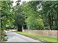
Estate wall and gateway, Watlington Park
The estate dates back to the 13th Century. Much of it has been transferred to the National Trust. The 18th Century mansion and immediate grounds remain in private hands.
Image: © Simon Mortimer
Taken: 7 Sep 2022
0.06 miles
2
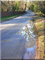
Road between Greenfield and Christmas Common
On the left is part of the long wall that encloses Watlington Park.
Image: © Andrew Smith
Taken: 30 Mar 2008
0.08 miles
3
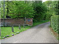
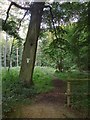
Eastern path into Watlington Park
Just south of Christmas Common is Watlington Park. This is the eastern footpath entrance into the area.
Image: © Jonathan Dew
Taken: 8 May 2005
0.12 miles
4
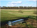
Pasture and woodland, Greenfield
Looking across to Queen Wood from the northern end of Greenfield Wood.
Image: © Andrew Smith
Taken: 30 Mar 2008
0.18 miles
5
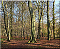
Woodland near Christmas Common
Mostly beechwoods, with some larches.
Image: © Stefan Czapski
Taken: 3 Aug 2012
0.22 miles
6
Elegant beech tree, Christmas Common, Oxfordshire
Image: © Oswald Bertram
Taken: 20 Nov 2015
0.23 miles