IMAGES TAKEN NEAR TO
Watlington Road, WATLINGTON, OX49 5DX
Introduction
This page details the photographs taken nearby to Watlington Road, OX49 5DX by members of the Geograph project.
The Geograph project started in 2005 with the aim of publishing, organising and preserving representative images for every square kilometre of Great Britain, Ireland and the Isle of Man.

There are currently over 7.5m images from over14,400 individuals and you can help contribute to the project by visiting https://www.geograph.org.uk
Image Map
Images are licensed for reuse under creativecommons.org/licenses/by-sa/2.0
Notes
- Clicking on the map will re-center to the selected point.
- The higher the marker number, the further away the image location is from the centre of the postcode.
Image Listing (6 Images Found)
Images are licensed for reuse under creativecommons.org/licenses/by-sa/2.0
Image
Details
Distance
1
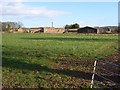
Model Farm, Shirburn
There is a large array of old and new buildings. The old ones were built in 1856. The engine house with its chimney is most prominent. They are part of the estate of Shirburn Castle, the seat of the Earl of Macclesfield.
Image: © Andrew Smith
Taken: 1 Mar 2008
0.10 miles
2
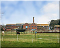
Model Farm
A Victorian steam powered farm, with mechanised systems for feeding and heating etc, all housed in these purpose built factory like buildings. Powered by coal brought in by train on the Watlington branch line a short distance away.
The buildings are still in use, and some of the machinery is still in place.
Image: © Des Blenkinsopp
Taken: 21 Mar 2016
0.11 miles
4
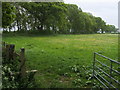
Oxfordshire Way
Oxfordshire Way by Model Farm
Image: © Shaun Ferguson
Taken: 17 May 2009
0.15 miles
5
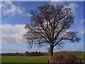
Oak, Shirburn
Standing beside the Oxfordshire Way north of Model Farm. On the evidence of my brief visit, it seems that the Shirburn Estate liked its oak trees.
Image: © Andrew Smith
Taken: 1 Mar 2008
0.22 miles
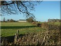
6
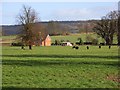
Pasture, Shirburn
A cottage south of Model Farm with the Chilterns rising beyond.
Image: © Andrew Smith
Taken: 1 Mar 2008
0.23 miles