IMAGES TAKEN NEAR TO
Hill Road, WATLINGTON, OX49 5AE
Introduction
This page details the photographs taken nearby to Hill Road, OX49 5AE by members of the Geograph project.
The Geograph project started in 2005 with the aim of publishing, organising and preserving representative images for every square kilometre of Great Britain, Ireland and the Isle of Man.

There are currently over 7.5m images from over14,400 individuals and you can help contribute to the project by visiting https://www.geograph.org.uk
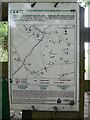
Image Map
Images are licensed for reuse under creativecommons.org/licenses/by-sa/2.0
Notes
- Clicking on the map will re-center to the selected point.
- The higher the marker number, the further away the image location is from the centre of the postcode.
Image Listing (12 Images Found)
Images are licensed for reuse under creativecommons.org/licenses/by-sa/2.0
Image
Details
Distance
2
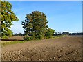
Farmland, Watlington
Recently ploughed fields to the north of Hill Road.
Image: © Andrew Smith
Taken: 1 Oct 2011
0.18 miles
4
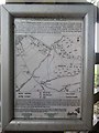
Conservation Walks Notice by Watlington Hill (1)
Located on a fence by the Ridgeway, this notice has the following wording with a map of the surrounding area:
Above the map
Welcome to Watlington Park. A permissive path has been created linking the Ridgeway (Icknield Way) National Trail with a local footpath leading to Watlington Hill Site of Special Scientific Interest. This allows a number of circular walks to be carried out, avoiding local roads, on the edge of the Chiltern Hills. Land over which the footpath passes is being managed to encourage a typical downland flora to develop.
Below the map
This access has been provided under the Department for Environment, Food & Rural Affairs' farm conservation schemes, which help farmers and land managers protect and improve the countryside, its wildlife and history. It is permissive access and no new rights of way are being created. Existing rights of way are not affected. Please follow the Country Code and observe any other requirements shown above. Do not disturb wildlife, livestock or other visitors and in particular keep dogs under control. This is working farmland so please take care; people using this site do so at their own risk. Access ends in September 2012.
COUNTRYSIDE STEWARDSHIP SCHEME
ENVIRONMENTALLY SENSITIVE AREAS
defra
Image: © David Hillas
Taken: 27 Aug 2018
0.22 miles
5
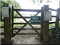
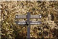
Notice on Gate by The Ridgeway
This photo shows a green notice "BULL IN FIELD" on a gate taken from The Ridgeway long distance footpath. However, I didn't notice the bull in the field at the time I took this photo, which was probably just as well. For SatNav purposes, the postcode of The Ridgeway at this location is OX49 5AF.
Image: © David Hillas
Taken: 27 Aug 2018
0.22 miles
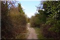
6
Conservation Walks Notice by Watlington Hill (2)
Located on a fence by the Ridgeway west of Watlington Hill, this notice has a map of the surrounding area with the following wording:
Above the map
This permissive footpath around the base of Watlington Hill, noted for its chalk grasses and wild flowers, links the Ridgeway National Trail, to another footpath on the south of the hill which itself links with a National Trust car park. Dogs should be kept on a lead at all times.
Below the map
COUNTRYSIDE STEWARDSHIP SCHEME
COUNTRYSIDE ACCESS SCHEME
ENVIRONMENTALLY SENSITIVE AREAS
This access has been provided under The Ministry of Agriculture, Fisheries and Food's farm conservation schemes, which help farmers and land managers protect and improve the countryside, its wildlife and history. It is permissive access and no new rights of way are being created. Existing rights of way are not affected. Please follow the Country Code and observe any other requirements shown above. Do not disturb wildlife, livestock or other visitors and in particular keeps dogs under control. This is working farmland so please take care; people using this site do so at their own risk. Access ends in September 2002.
Image: © David Hillas
Taken: 27 Aug 2018
0.22 miles
7
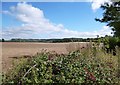
Towards The Chilterns
View over farmland to the Chiltern escarpment.
Image: © Des Blenkinsopp
Taken: 20 Sep 2013
0.22 miles
9
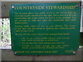
Countryside Commission Notice near Watlington Hill
Located on the Ridgeway off Hill Road, this green notice has the following wording:
COUNTRYSIDE STEWARDSHIP
The occupier allows free public access to the private fields or waymarked paths identified by this sign. This is part of a 10-year conservation plan under which the land is being managed. You are welcome to walk and enjoy the countryside here until further notice.
Existing public rights of way are not affected. The owner of this land does not intend to dedicate any additional public rights of way over it.
To help with the conservation of this managed land, kindly:
take care not to disturb wildlife and farm stock, keep dogs under control, and leave gates as you find them;
take your litter home and do nothing to cause a fire; and
PLEASE: no camping, overnight stays, motor vehicles, firearms, or any other activities that will disturb other visitors.
THANK YOU AND ENJOY YOUR VISIT
COUNTRYSIDE COMMISSION
Image: © David Hillas
Taken: 27 Aug 2018
0.23 miles
