Conservation Walks Notice by Watlington Hill (2)
Introduction
The photograph on this page of Conservation Walks Notice by Watlington Hill (2) by David Hillas as part of the Geograph project.
The Geograph project started in 2005 with the aim of publishing, organising and preserving representative images for every square kilometre of Great Britain, Ireland and the Isle of Man.

There are currently over 7.5m images from over 14,400 individuals and you can help contribute to the project by visiting https://www.geograph.org.uk
Conservation Walks Notice by Watlington Hill (2)
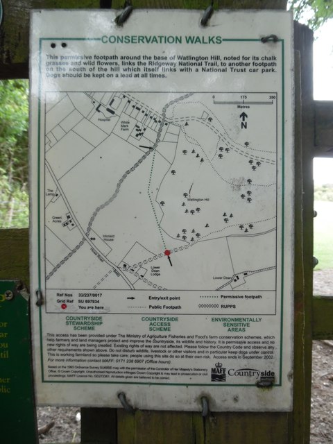
Image: © David Hillas Taken: 27 Aug 2018
Located on a fence by the Ridgeway west of Watlington Hill, this notice has a map of the surrounding area with the following wording: Above the map This permissive footpath around the base of Watlington Hill, noted for its chalk grasses and wild flowers, links the Ridgeway National Trail, to another footpath on the south of the hill which itself links with a National Trust car park. Dogs should be kept on a lead at all times. Below the map COUNTRYSIDE STEWARDSHIP SCHEME COUNTRYSIDE ACCESS SCHEME ENVIRONMENTALLY SENSITIVE AREAS This access has been provided under The Ministry of Agriculture, Fisheries and Food's farm conservation schemes, which help farmers and land managers protect and improve the countryside, its wildlife and history. It is permissive access and no new rights of way are being created. Existing rights of way are not affected. Please follow the Country Code and observe any other requirements shown above. Do not disturb wildlife, livestock or other visitors and in particular keeps dogs under control. This is working farmland so please take care; people using this site do so at their own risk. Access ends in September 2002.
Images are licensed for reuse under creativecommons.org/licenses/by-sa/2.0
Image Location
Latitude
51.638416
Longitude
-0.993066