IMAGES TAKEN NEAR TO
Rowan Grove, OXFORD, OX4 7FD
Introduction
This page details the photographs taken nearby to Rowan Grove, OX4 7FD by members of the Geograph project.
The Geograph project started in 2005 with the aim of publishing, organising and preserving representative images for every square kilometre of Great Britain, Ireland and the Isle of Man.

There are currently over 7.5m images from over14,400 individuals and you can help contribute to the project by visiting https://www.geograph.org.uk
Image Map
Images are licensed for reuse under creativecommons.org/licenses/by-sa/2.0
Notes
- Clicking on the map will re-center to the selected point.
- The higher the marker number, the further away the image location is from the centre of the postcode.
Image Listing (11 Images Found)
Images are licensed for reuse under creativecommons.org/licenses/by-sa/2.0
Image
Details
Distance
1
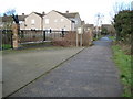
Oxford: Roman Road in Blackbird Leys
This unprepossessing little back lane is in fact the route of a 16 mile long Roman road that was, and still is, used to define the eastern boundary of the parish of Sandford-on-Thames. The route here crosses Northfield Brook.
Image: © Nigel Cox
Taken: 16 Jan 2008
0.03 miles
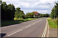
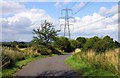
6
Roman Road
Route of Roman Road Blackberry Lane heading out to Grenoble Road
Image: © Shaun Ferguson
Taken: 28 Jun 2009
0.14 miles
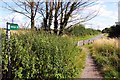
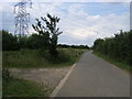
7

Minor road to the electricity substation
Image: © Steve Daniels
Taken: 27 Jul 2009
0.14 miles
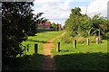
8
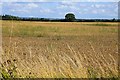
Looking across a field by Greater Leys
Image: © Steve Daniels
Taken: 27 Jul 2009
0.16 miles
9

Pylon near Sandford Brake
One of the five transmission lines which converge at the large sub-station at Sandford Brake, near Cowley.
Image: © David Hawgood
Taken: 23 Jun 2006
0.21 miles
10
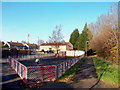
Roman Road, Blackbird Leys
The ancient route of the Dorchester to Bicester Roman road has been preserved intact as a well used public footpath through the large Oxford suburb of Blackbird Leys.
The houses beyond the playground are on Sorrel Road.
Image: © Des Blenkinsopp
Taken: 30 Nov 2011
0.23 miles