IMAGES TAKEN NEAR TO
Comfrey Road, OXFORD, OX4 6SP
Introduction
This page details the photographs taken nearby to Comfrey Road, OX4 6SP by members of the Geograph project.
The Geograph project started in 2005 with the aim of publishing, organising and preserving representative images for every square kilometre of Great Britain, Ireland and the Isle of Man.

There are currently over 7.5m images from over14,400 individuals and you can help contribute to the project by visiting https://www.geograph.org.uk
Image Map
Images are licensed for reuse under creativecommons.org/licenses/by-sa/2.0
Notes
- Clicking on the map will re-center to the selected point.
- The higher the marker number, the further away the image location is from the centre of the postcode.
Image Listing (19 Images Found)
Images are licensed for reuse under creativecommons.org/licenses/by-sa/2.0
Image
Details
Distance
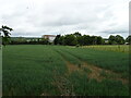
1
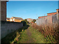
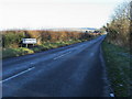
End of the Roman Road
This scruffy bit of footpath between housing and an electricity station is an ancient route following the Roman road between Dorchester and Bicester.
The course is still fairly intact as a bridleway coming northwards from Dorchester, apart from a short vanished section near Berinsfield, until you get to here where industrial buildings block the alignment.
The route briefly surfaces again for a few hundred metres past the BMW factory but then is lost again under housing and the eastern by-pass until the southern approaches to Otmoor.
Image: © Des Blenkinsopp
Taken: 30 Nov 2011
0.08 miles
2
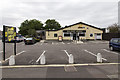
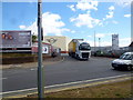
Bullnose Morris
A Hungry Horse public house on Cuddesdon Way.
The name refers to the Bullnose Morris motor car built at the factory just north of here, where the current BMW Mini range is produced.
Image: © David P Howard
Taken: 21 Aug 2014
0.09 miles
3
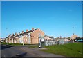
A Street in Blackbird Leys
Blackbird Leys is a new suburb to the south east of Oxford.
Image: © Des Blenkinsopp
Taken: 30 Nov 2011
0.09 miles
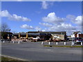
6
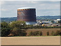
Cowley gasometer (gas-holder)
Gas holder at Cowley viewed over the fields from Garsington
Image: © David Hawgood
Taken: 24 Sep 2006
0.16 miles
7
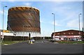
Oxford: Cowley gasometer
On Oxford Road, Cowley, viewed from its junction with the B480 Watlington Road.
Image: © Nigel Cox
Taken: 16 Jan 2008
0.16 miles
8
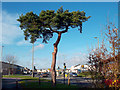
Tree and Traffic Lights
The junction of Watlington Road and Sandy Lane.
Image: © Des Blenkinsopp
Taken: 30 Nov 2011
0.16 miles
9
Oxford Road
Oxford Road with an early sign to Garsington which is a mile further along the road
Image: © Shaun Ferguson
Taken: 7 Dec 2008
0.20 miles
10
Mini Works, Gate 10
Looking across the Watlington Road.
Image: © Jonathan Billinger
Taken: 12 Jul 2017
0.21 miles