IMAGES TAKEN NEAR TO
Sandford-on-Thames, OXFORD, OX4 4XU
Introduction
This page details the photographs taken nearby to OX4 4XU by members of the Geograph project.
The Geograph project started in 2005 with the aim of publishing, organising and preserving representative images for every square kilometre of Great Britain, Ireland and the Isle of Man.

There are currently over 7.5m images from over14,400 individuals and you can help contribute to the project by visiting https://www.geograph.org.uk
Image Map
Images are licensed for reuse under creativecommons.org/licenses/by-sa/2.0
Notes
- Clicking on the map will re-center to the selected point.
- The higher the marker number, the further away the image location is from the centre of the postcode.
Image Listing (19 Images Found)
Images are licensed for reuse under creativecommons.org/licenses/by-sa/2.0
Image
Details
Distance
1
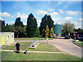
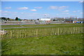
Rain Gauge Inspection at Oxford STW
Just a random shot of part of Thames Water's Oxford sewage works.
My colleague is inspecting a rain gauge.
There are hundreds of manually read rain gauges all over the country which are looked at every day by on-site observers. The results are sent to the Environment Agency and Met. Office and contribute to the ever growing national rainfall data base.
Each gauge is inspected by the Met. Office every 3 years to make sure that it is in an acceptable condition for accurate recording. (i.e. not leaning sideways, bent by grass cutters, overhung by branches, bits stolen etc.)
Image: © Des Blenkinsopp
Taken: 9 May 2010
0.05 miles
2

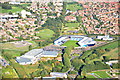
Oxford sewage treatment works
The works include dewatering systems to change sludge into dry cakes to use as agricultural fertiliser.
Image: © David Hawgood
Taken: 23 Jun 2006
0.06 miles
3
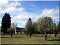
Orchard in the Sewage Works
I see there's already a picture contributed of this obscure corner of Oxford Sewage Works Image but this particular image isn't so much about the equipment, rather the unusual sight of a neatly maintained small orchard of fruit trees within the operational area.
Image: © Des Blenkinsopp
Taken: 9 May 2010
0.10 miles
4
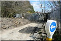
Sewage works - back entrance
Sometimes Shakespeare's Way goes through less salubrious places. Here we are approaching the rear entrance of a sewage works, where the footpath turns right (despite the bollard) for a circumnavigation of the perimeter fence. Lovely.
Image: © Graham Horn
Taken: 6 Apr 2013
0.11 miles
5
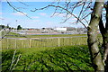
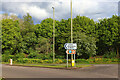
Route past the sewage works
Shakespeare's Way sometimes visits less salubrious places. The map here was not promising, but perhaps surprisingly the footpath past the southern side of the sewage works was not too bad. There was no smell and behind us are open fields.
Image: © Graham Horn
Taken: 6 Apr 2013
0.11 miles
6
Route past the sewage works
Shakespeare's Way sometimes visits less salubrious places. The map here was not promising, but perhaps surprisingly the footpath past the southern side of the sewage works was not too bad. There was no smell and behind us are open fields.
Image: © Graham Horn
Taken: 6 Apr 2013
0.11 miles
10
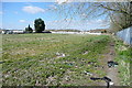
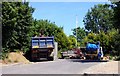
Between the caravan park and the sewage works
Sometimes Shakespeare's Way visits less salubrious places. Here the footpath has the sewage works on the right and a mobile home park on the left. The latter is fine, but this area of open land between the two has become a fly tipping area. Not pleasant.
Image: © Graham Horn
Taken: 6 Apr 2013
0.17 miles