IMAGES TAKEN NEAR TO
Denton Lane, OXFORD, OX44 9JN
Introduction
This page details the photographs taken nearby to Denton Lane, OX44 9JN by members of the Geograph project.
The Geograph project started in 2005 with the aim of publishing, organising and preserving representative images for every square kilometre of Great Britain, Ireland and the Isle of Man.

There are currently over 7.5m images from over14,400 individuals and you can help contribute to the project by visiting https://www.geograph.org.uk
Image Map (Loading...)


Getting Data...Please wait
Leaflet Map data © OpenStreetMap
Images are licensed for reuse under creativecommons.org/licenses/by-sa/2.0
Notes
- Clicking on the map will re-center to the selected point.
- The higher the marker number, the further away the image location is from the centre of the postcode.
Image Listing (9 Images Found)
Images are licensed for reuse under creativecommons.org/licenses/by-sa/2.0
Image
Details
Distance
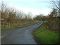
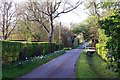
1
Denton Lane
Denton Lane passing Bridleway to South End at The Platt
Image: © Shaun Ferguson
Taken: 28 Jun 2009
0.00 miles
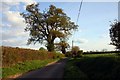
3
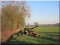
Pile of Tree Trunks
Farmland and timber by Denton Lane.
Image: © Des Blenkinsopp
Taken: 20 Jan 2016
0.12 miles
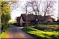
5
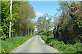
Denton Lane
Heading north towards Denton.
Image: © Robin Webster
Taken: 25 Apr 2021
0.16 miles
7
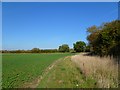
Farmland, Denton
A footpath beside a crop of oil-seed rape to the north of Chippinghurst Manor.
Image: © Andrew Smith
Taken: 22 Oct 2011
0.20 miles
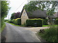
8
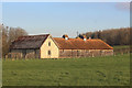
Buildings near Chippinghurst Manor
These look like conversions. A stone barn and a granary or maltings or similar.
Image: © Des Blenkinsopp
Taken: 20 Jan 2016
0.22 miles