IMAGES TAKEN NEAR TO
Pettiwell, OXFORD, OX44 9DB
Introduction
This page details the photographs taken nearby to Pettiwell, OX44 9DB by members of the Geograph project.
The Geograph project started in 2005 with the aim of publishing, organising and preserving representative images for every square kilometre of Great Britain, Ireland and the Isle of Man.

There are currently over 7.5m images from over14,400 individuals and you can help contribute to the project by visiting https://www.geograph.org.uk
Image Map
Images are licensed for reuse under creativecommons.org/licenses/by-sa/2.0
Notes
- Clicking on the map will re-center to the selected point.
- The higher the marker number, the further away the image location is from the centre of the postcode.
Image Listing (49 Images Found)
Images are licensed for reuse under creativecommons.org/licenses/by-sa/2.0
Image
Details
Distance
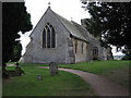

8
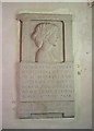
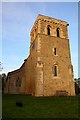
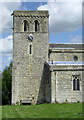
Memorial, St. Mary's, Garsington, Oxfordshire
The memorial is to Lady Ottoline Morrell, the effective founder of the Bloomsbury group. Her home of Garsington Manor was the centre of the cultural life of a very select group of people as diverse as John Maynard Keynes and T.S.Eliot, and of course Virginia Woolf.
Image: © nick macneill
Taken: 14 Feb 1991
0.08 miles