IMAGES TAKEN NEAR TO
Elm Drive, OXFORD, OX44 9AG
Introduction
This page details the photographs taken nearby to Elm Drive, OX44 9AG by members of the Geograph project.
The Geograph project started in 2005 with the aim of publishing, organising and preserving representative images for every square kilometre of Great Britain, Ireland and the Isle of Man.

There are currently over 7.5m images from over14,400 individuals and you can help contribute to the project by visiting https://www.geograph.org.uk
Image Map (Loading...)


Getting Data...Please wait
Leaflet Map data © OpenStreetMap
Images are licensed for reuse under creativecommons.org/licenses/by-sa/2.0
Notes
- Clicking on the map will re-center to the selected point.
- The higher the marker number, the further away the image location is from the centre of the postcode.
Image Listing (16 Images Found)
Images are licensed for reuse under creativecommons.org/licenses/by-sa/2.0
Image
Details
Distance
1
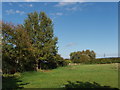
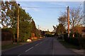
Pasture, Garsington
View from footpath just a few yards outside the built up area of Garsington.
Image: © David Hawgood
Taken: 24 Sep 2006
0.02 miles
2
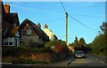
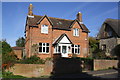
Elm Drive, Garsington
Houses on the road up to the Post Office.
Image: © David Hawgood
Taken: 24 Sep 2006
0.06 miles
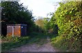
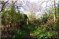
7
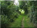
Footpath nearing Oxford Road
Footpath from Horspath nearing Oxford Road Garsington
Image: © Shaun Ferguson
Taken: 28 Jun 2009
0.16 miles