IMAGES TAKEN NEAR TO
Cold Harbour, OXFORD, OX44 7UG
Introduction
This page details the photographs taken nearby to Cold Harbour, OX44 7UG by members of the Geograph project.
The Geograph project started in 2005 with the aim of publishing, organising and preserving representative images for every square kilometre of Great Britain, Ireland and the Isle of Man.

There are currently over 7.5m images from over14,400 individuals and you can help contribute to the project by visiting https://www.geograph.org.uk
Image Map
Images are licensed for reuse under creativecommons.org/licenses/by-sa/2.0
Notes
- Clicking on the map will re-center to the selected point.
- The higher the marker number, the further away the image location is from the centre of the postcode.
Image Listing (8 Images Found)
Images are licensed for reuse under creativecommons.org/licenses/by-sa/2.0
Image
Details
Distance
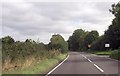
2
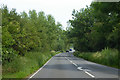
Stadhampton Road to Little Milton
The A329 runs from Stadhampton to Little Milton.
Image: © Steve Daniels
Taken: 25 Jan 2014
0.05 miles
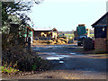
3
The lodge at Coldharbour Farm, beside A329
Image: © Roger Templeman
Taken: 10 Apr 2014
0.06 miles
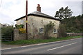
5
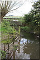
Hangman's Bridge for A329 over Haseley Brook
Image: © Roger Templeman
Taken: 10 Apr 2014
0.19 miles
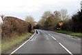
6
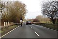
Stadhampton Road crosses Hangman Bridge
The A329 runs from Stadhampton to Little Milton.
Image: © Steve Daniels
Taken: 25 Jan 2014
0.19 miles
7
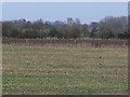
Sheephouse Barn Farm - Winter Fields
View North East towards Parish Church at Little Milton
Image: © William Wells
Taken: 23 Dec 2005
0.20 miles