IMAGES TAKEN NEAR TO
The Green, OXFORD, OX44 7SU
Introduction
This page details the photographs taken nearby to The Green, OX44 7SU by members of the Geograph project.
The Geograph project started in 2005 with the aim of publishing, organising and preserving representative images for every square kilometre of Great Britain, Ireland and the Isle of Man.

There are currently over 7.5m images from over14,400 individuals and you can help contribute to the project by visiting https://www.geograph.org.uk
Image Map (Loading...)


Getting Data...Please wait
Leaflet Map data © OpenStreetMap
Images are licensed for reuse under creativecommons.org/licenses/by-sa/2.0
Notes
- Clicking on the map will re-center to the selected point.
- The higher the marker number, the further away the image location is from the centre of the postcode.
Image Listing (86 Images Found)
Images are licensed for reuse under creativecommons.org/licenses/by-sa/2.0
Image
Details
Distance
1
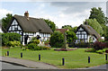
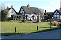
Houses on the green, Chalgrove
Both date from the 17th century and are Listed Grade II.
Image: © Alan Murray-Rust
Taken: 9 Jul 2014
0.01 miles
2
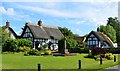
Village green, Chalgrove, Oxfordshire
Image: © Oswald Bertram
Taken: 6 Jun 2015
0.01 miles
3
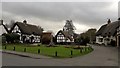
The green at Chalgrove
This looks like an improvised green to me, a former house plot perhaps. Does anybody know?
Image: © Chris Brown
Taken: 22 Feb 2017
0.01 miles
4
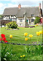
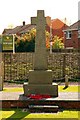
Chalgrove village green
The attractive village green hosts the war memorial and is surrounded by immaculate thatched cottages. We are just setting out on the next leg of Shakespeare's Way.
Image: © Graham Horn
Taken: 4 May 2013
0.01 miles
6
Chalgrove village green
The village green hosts the war memorial and some of the older properties in this attractive linear village. We finished this leg of our Shakespeare's Way walk here and will start the next one in a few weeks time.
Image: © Graham Horn
Taken: 6 Apr 2013
0.02 miles
7
Houses on the green, Chalgrove
Originally two houses, now merged. The left hand, timber-framed, section is 17th century, the stone built section early 18th century. Listed Grade II.
Image: © Alan Murray-Rust
Taken: 9 Jul 2014
0.02 miles
8
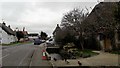
Chalgrove High Street and residents
The brook is integral to the scene in Chalgrove High Street.
Image: © Chris Brown
Taken: 22 Feb 2017
0.02 miles
9
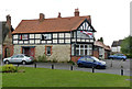
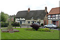
The Crown, Chalgrove
The black and white effect is entirely superficial.
Image: © Alan Murray-Rust
Taken: 9 Jul 2014
0.02 miles
10
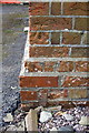
Benchmark on Chalgrove Community Primary School
Ordnance Survey cut mark benchmark described on the Bench Mark Database at http://www.bench-marks.org.uk/bm56912
Image: © Roger Templeman
Taken: 4 Apr 2014
0.03 miles