IMAGES TAKEN NEAR TO
Stadhampton Road, OXFORD, OX44 7QD
Introduction
This page details the photographs taken nearby to Stadhampton Road, OX44 7QD by members of the Geograph project.
The Geograph project started in 2005 with the aim of publishing, organising and preserving representative images for every square kilometre of Great Britain, Ireland and the Isle of Man.

There are currently over 7.5m images from over14,400 individuals and you can help contribute to the project by visiting https://www.geograph.org.uk
Image Map (Loading...)


Getting Data...Please wait
Leaflet Map data © OpenStreetMap
Images are licensed for reuse under creativecommons.org/licenses/by-sa/2.0
Notes
- Clicking on the map will re-center to the selected point.
- The higher the marker number, the further away the image location is from the centre of the postcode.
Image Listing (92 Images Found)
Images are licensed for reuse under creativecommons.org/licenses/by-sa/2.0
Image
Details
Distance
1
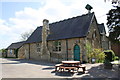
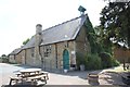
Little Milton C of E Primary School
There is an OS benchmark Image on the side of the school at the near angle, left of the salt bin
Image: © Roger Templeman
Taken: 10 Apr 2014
0.00 miles
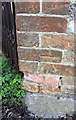
2
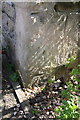
Ground level benchmark on Little Milton Primary School
Ordnance Survey cut mark benchmark described on the Bench Mark Database at http://www.bench-marks.org.uk/bm38925
Image: © Roger Templeman
Taken: 10 Apr 2014
0.00 miles
3
Entrance to the school
Well, the gate was open and I spotted a benchmark on the corner by the dustbin, so it seemed rude not to take a photo of this wonderful old Victorian school.
Image: © Bill Nicholls
Taken: 31 Jul 2011
0.01 miles
4
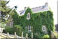
Ivy on the school
It's some kind of creeper which is gradually covering the C of E school in Little Milton.
Image: © Bill Nicholls
Taken: 31 Jul 2011
0.01 miles
5
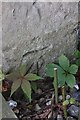
Benchmark on the school
Had it not been for the plant being cut back I'd have missed this benchmark while walking by as it is right on ground level. Image
Image: © Bill Nicholls
Taken: 31 Jul 2011
0.01 miles
6
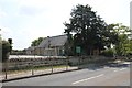
School on the corner
The Church of England primary school in Little Milton
Image: © Bill Nicholls
Taken: 31 Jul 2011
0.01 miles
7
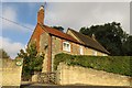
Plough House on Church Hill
Plough House was converted from the Plough, a former Morrells pub.
Image: © Steve Daniels
Taken: 30 Sep 2014
0.04 miles
8
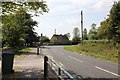
House on the bend
Looking towards the bend at the bottom of Church Hill in Little Milton and the bend which takes you out of the village.
Image: © Bill Nicholls
Taken: 31 Jul 2011
0.04 miles
9
Benchmark on building at Ostlers Brook
Ordnance Survey cut mark benchmark described on the Bench Mark Database at http://www.bench-marks.org.uk/bm39031
Image: © Roger Templeman
Taken: 10 Apr 2014
0.05 miles
10

Cottage on the bend
The A329 heading out of Little Milton.
Image: © Bill Nicholls
Taken: 18 Feb 2012
0.05 miles