IMAGES TAKEN NEAR TO
Warpsgrove Lane, OXFORD, OX44 7BQ
Introduction
This page details the photographs taken nearby to Warpsgrove Lane, OX44 7BQ by members of the Geograph project.
The Geograph project started in 2005 with the aim of publishing, organising and preserving representative images for every square kilometre of Great Britain, Ireland and the Isle of Man.

There are currently over 7.5m images from over14,400 individuals and you can help contribute to the project by visiting https://www.geograph.org.uk
Image Map (Loading...)


Getting Data...Please wait
Leaflet Map data © OpenStreetMap
Images are licensed for reuse under creativecommons.org/licenses/by-sa/2.0
Notes
- Clicking on the map will re-center to the selected point.
- The higher the marker number, the further away the image location is from the centre of the postcode.
Image Listing (12 Images Found)
Images are licensed for reuse under creativecommons.org/licenses/by-sa/2.0
Image
Details
Distance
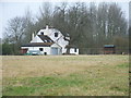
1
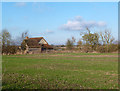
House at Warpsgrove
Warpsgrove seems to be just two houses, Manor House Farm and this place.
Image: © Des Blenkinsopp
Taken: 15 Jan 2013
0.07 miles
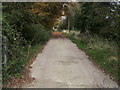
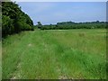
2
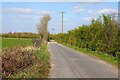
Footpath to Little Haseley
Footpath to Little Haseley at Warpsgrove
Image: © Shaun Ferguson
Taken: 18 Oct 2008
0.11 miles
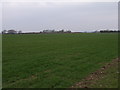
5
Farmland at Warpsgrove
Looking northeast.
Image: © Andrew Smith
Taken: 18 Mar 2006
0.19 miles
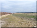
7
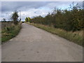
Lane to sewage works
Lane to sewage works near Warpsgrove
Image: © Shaun Ferguson
Taken: 18 Oct 2008
0.22 miles
8
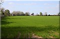
Farmland, Chalgrove
A track into the flat fields to the east of Warpsgrove,
Image: © Andrew Smith
Taken: 10 Jun 2018
0.22 miles