IMAGES TAKEN NEAR TO
Barton Fields Road, OXFORD, OX3 9WN
Introduction
This page details the photographs taken nearby to Barton Fields Road, OX3 9WN by members of the Geograph project.
The Geograph project started in 2005 with the aim of publishing, organising and preserving representative images for every square kilometre of Great Britain, Ireland and the Isle of Man.

There are currently over 7.5m images from over14,400 individuals and you can help contribute to the project by visiting https://www.geograph.org.uk
Image Map
Images are licensed for reuse under creativecommons.org/licenses/by-sa/2.0
Notes
- Clicking on the map will re-center to the selected point.
- The higher the marker number, the further away the image location is from the centre of the postcode.
Image Listing (22 Images Found)
Images are licensed for reuse under creativecommons.org/licenses/by-sa/2.0
Image
Details
Distance
1
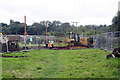
Temporary (hopefully) obstruction on footpath from Elsfield
Housing development on north side of the Northern By-Pass Road
Image: © Roger Templeman
Taken: 9 Sep 2015
0.11 miles
2
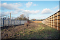
Not a nice path
This is the public footpath between Headington and Elsfield. The casual observer could be forgiven for thinking it was the frontier between two unfriendly nations. Electricity station on the left, while on the right it's not even a top-secret installation behind the fence, it's just a building site.
Image: © Des Blenkinsopp
Taken: 17 Jan 2018
0.11 miles
3

Barton Recreation Ground
The pitch is the home ground of Headington Amateurs F.C.
Image: © Steve Daniels
Taken: 3 Apr 2011
0.14 miles
4
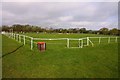
Barton Recreation Ground
The pitch is the home ground of Headington Amateurs F.C.
Image: © Steve Daniels
Taken: 3 Apr 2011
0.14 miles
5
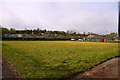
Disused bowls green at Barton Recreation Ground
Image: © Steve Daniels
Taken: 3 Apr 2011
0.14 miles
6
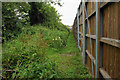
Footpath next to a new development
The developers have kept the footpath open though the land here is not getting any maintenance. The fence is the western edge of the Redrow The Steeples development.
Image: © Bill Boaden
Taken: 3 Jul 2020
0.15 miles
7

Weathered benchmark on Lower Farm House
Ordnance Survey cut mark benchmark described on the Bench Mark Database at https://www.bench-marks.org.uk/bm70486
Image: © Roger Templeman
Taken: 9 Sep 2015
0.16 miles
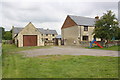
8

Lower Farm House
There is an OS benchmark Image on the near corner of the house at the junction with the abutting stone wall
Image: © Roger Templeman
Taken: 9 Sep 2015
0.16 miles
9

Barton Fields Road
This is the entrance to The Steeples, part of the new Barton Park housing development, with this part being built by Redrow.
Image: © Bill Boaden
Taken: 3 Jul 2020
0.16 miles
10
Housing at Lower Farm: converted barn and farmhouse
Image: © Roger Templeman
Taken: 9 Sep 2015
0.16 miles