IMAGES TAKEN NEAR TO
Beckley, OXFORD, OX3 9TY
Introduction
This page details the photographs taken nearby to OX3 9TY by members of the Geograph project.
The Geograph project started in 2005 with the aim of publishing, organising and preserving representative images for every square kilometre of Great Britain, Ireland and the Isle of Man.

There are currently over 7.5m images from over14,400 individuals and you can help contribute to the project by visiting https://www.geograph.org.uk
Image Map
Images are licensed for reuse under creativecommons.org/licenses/by-sa/2.0
Notes
- Clicking on the map will re-center to the selected point.
- The higher the marker number, the further away the image location is from the centre of the postcode.
Image Listing (15 Images Found)
Images are licensed for reuse under creativecommons.org/licenses/by-sa/2.0
Image
Details
Distance
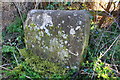
1
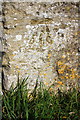
Benchmark on New Inn Farm wall
Ordnance Survey cut mark benchmark described on the Bench Mark Database at www.bench-marks.org.uk/bm68348
Image: © Roger Templeman
Taken: 27 Feb 2019
0.02 miles
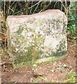
2
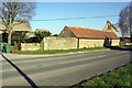
Barn at New Inn Farm beside B4027
There is an OS benchmark Image on the wall angle at the left hand end of the stone wall at the junction with the lower stone wall and below farm name sign
Image: © Roger Templeman
Taken: 27 Feb 2019
0.03 miles
3
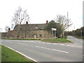
The former New Inn
The building presumably gave its name to New Inn Farm opposite, and to New Inn Road (right of photo).
Image: © Stephen Craven
Taken: 24 Mar 2010
0.04 miles
4
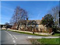
New Inn Farmhouse, Beckley
Built in C18 as an inn. See http://www.britishlistedbuildings.co.uk/en-246526-new-inn-farmhouse-beckley-and-stowood-ox for entry in British Listed Buildings.
Image: © Bikeboy
Taken: 22 Mar 2015
0.05 miles
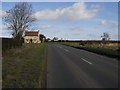
5
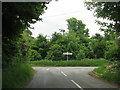
The road from Beckley meets the B4027
Image: © Sarah Charlesworth
Taken: 1 Jun 2010
0.06 miles
6
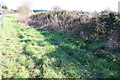
Boundary stone on verge of B4027 opposite Royal Oak Farm
There is an closeup image of the stone at Image
Image: © Roger Templeman
Taken: 27 Feb 2019
0.14 miles
8
Old Boundary Marker by the B4027, Stow Wood, Beckley
Parish Boundary Marker by the B4027, in parish of Beckley and Stow Wood (South Oxfordshire District), beside Stow Wood, 150m SE of Royal Oak Farm (PYO farm shop), behind wide grass verge, beside end of field hedge line; opposite where public footpath emerges.
Surveyed
Milestone Society National ID: OX_LWI52Mpb.
Image: © Milestone Society
Taken: Unknown
0.15 miles
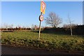
9
Bayswater Road
Bayswater Road approaching junction with B4027
Image: © Shaun Ferguson
Taken: 20 Feb 2009
0.18 miles
10
Bayswater Road at the corner of the B4027
Image: © David Howard
Taken: 21 Jan 2020
0.18 miles