IMAGES TAKEN NEAR TO
Nourse Close, OXFORD, OX3 9TJ
Introduction
This page details the photographs taken nearby to Nourse Close, OX3 9TJ by members of the Geograph project.
The Geograph project started in 2005 with the aim of publishing, organising and preserving representative images for every square kilometre of Great Britain, Ireland and the Isle of Man.

There are currently over 7.5m images from over14,400 individuals and you can help contribute to the project by visiting https://www.geograph.org.uk
Image Map
Images are licensed for reuse under creativecommons.org/licenses/by-sa/2.0
Notes
- Clicking on the map will re-center to the selected point.
- The higher the marker number, the further away the image location is from the centre of the postcode.
Image Listing (118 Images Found)
Images are licensed for reuse under creativecommons.org/licenses/by-sa/2.0
Image
Details
Distance
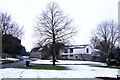
1
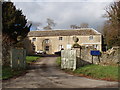
Nourse Close, Woodeaton
The village has wide grass verges and this modern development kept them.
Image: © David Hawgood
Taken: 1 Mar 2007
0.00 miles
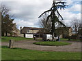
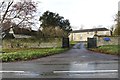
2
Road through Woodeaton
The road running through Woodeaton from near the Manor.
Image: © Bill Nicholls
Taken: 16 Jan 2014
0.04 miles
3
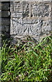
Benchmark on Woodeaton Manor School wall pier
Ordnance Survey cut mark benchmark described on the Bench Mark Database at http://www.bench-marks.org.uk/bm55736
Image: © Roger Templeman
Taken: 17 Mar 2014
0.05 miles
4
Woodeaton Manor School
This has been run by Oxfordshire County Council as a special needs school.
Image: © David Hawgood
Taken: 1 Mar 2007
0.05 miles
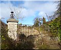
5
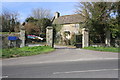
Entrance gateway to Woodeaton Manor School
There is an OS benchmark Image on the wall pier near the left hand side of the image
Image: © Roger Templeman
Taken: 17 Mar 2014
0.05 miles
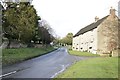
6
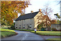
Old Upper Farmhouse, Woodeaton
A grade II listed building from around 1700.
Image: © Robin Webster
Taken: 13 Nov 2016
0.06 miles
7
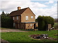
House in Woodeaton
At the north end of the small village.
Image: © David Hawgood
Taken: 1 Mar 2007
0.08 miles
8
Woodeaton Quarry Gates
I doubt these fancy gates were used even when the quarry was working. Another 3 or 4 paces and there's a cliff edge.
The quarry, where dinosaur footprints have been found, is a SSSI and an excellent place for fossils, hence recent controversy over plans to use it as a garbage tip. http://www.bbc.co.uk/news/uk-england-oxfordshire-17743016
Image: © Des Blenkinsopp
Taken: 7 Nov 2012
0.09 miles
9
School Entrance
This was part of the Manor but now is part of Manor School in Woodeaton
Image: © Bill Nicholls
Taken: 16 Jan 2014
0.09 miles