IMAGES TAKEN NEAR TO
Harolde Close, OXFORD, OX3 9SQ
Introduction
This page details the photographs taken nearby to Harolde Close, OX3 9SQ by members of the Geograph project.
The Geograph project started in 2005 with the aim of publishing, organising and preserving representative images for every square kilometre of Great Britain, Ireland and the Isle of Man.

There are currently over 7.5m images from over14,400 individuals and you can help contribute to the project by visiting https://www.geograph.org.uk
Image Map
Images are licensed for reuse under creativecommons.org/licenses/by-sa/2.0
Notes
- Clicking on the map will re-center to the selected point.
- The higher the marker number, the further away the image location is from the centre of the postcode.
Image Listing (24 Images Found)
Images are licensed for reuse under creativecommons.org/licenses/by-sa/2.0
Image
Details
Distance
1
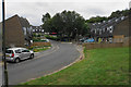
Harolde Close
Part of an estate where all the houses are built in the same unique style.
Image: © Bill Boaden
Taken: 3 Jul 2020
0.02 miles
2

Cycle path by the Oxford ring road
The path off Barton Road gives a choice of going under the ring road or else running along this side of it.
Image: © Bill Boaden
Taken: 3 May 2014
0.10 miles
3
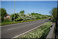
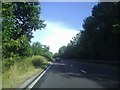
The Oxford ring road
Traversing the eastern side of the city. Spring flowers are in full bloom.
Image: © Bill Boaden
Taken: 3 May 2014
0.11 miles
4

Semis on the bend of Barton Village Road
The concrete skirt on the side of the near house conceals an Ordnance Survey benchmark
Image: © Roger Templeman
Taken: 9 Sep 2015
0.11 miles
5
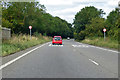
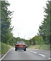
A40 North Way heading west
A dual carriageway bypassing Oxford to the north.
Image: © Robin Webster
Taken: 11 Aug 2019
0.13 miles
7
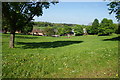
Green space by Wick Close
A pleasant green area in the Barton housing estate.
Image: © Bill Boaden
Taken: 3 May 2014
0.13 miles
9
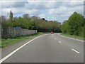
The A40 Northern Bypass, Headington
This part of the A40 forms one side of the Oxford Ring Road, which contains most but not all of the built up area.
Image: © David Howard
Taken: 29 Jul 2013
0.15 miles
10
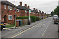
Fettiplace Road
A residential street in Barton which is on a bus route.
Image: © Bill Boaden
Taken: 3 Jul 2020
0.16 miles