IMAGES TAKEN NEAR TO
Glynswood, CHINNOR, OX39 4JB
Introduction
This page details the photographs taken nearby to Glynswood, OX39 4JB by members of the Geograph project.
The Geograph project started in 2005 with the aim of publishing, organising and preserving representative images for every square kilometre of Great Britain, Ireland and the Isle of Man.

There are currently over 7.5m images from over14,400 individuals and you can help contribute to the project by visiting https://www.geograph.org.uk
Image Map
Images are licensed for reuse under creativecommons.org/licenses/by-sa/2.0
Notes
- Clicking on the map will re-center to the selected point.
- The higher the marker number, the further away the image location is from the centre of the postcode.
Image Listing (135 Images Found)
Images are licensed for reuse under creativecommons.org/licenses/by-sa/2.0
Image
Details
Distance
1
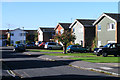
Druid's Walk, Chinnor
Houses in a cul-de-sac viewed from the junction with Glynswood.
Image: © Andrew Smith
Taken: 24 Oct 2010
0.04 miles
2
Siareys Close, Chinnor
A small cul-de-sac of large modern houses off Oakley Road, close to the centre of Chinnor village
Image: © Richard Dorrell
Taken: 14 Mar 2012
0.09 miles
3
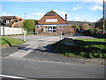
Chinnor Village Hall
Built in 1939 when the village of Chinnor had some 1,200 residents, the Hall now has to cater for a town which had a population of some 5,850 in the 2001 Census.
Image: © Nigel Cox
Taken: 30 Mar 2008
0.12 miles
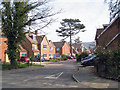
4
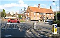
Chinnor: The Crown public house
The Crown is at the junction of Church Road with Station Road. The 1885 Ordnance Survey map shows a smithy next to the pub at a location over the top of the red car.
Image: © Nigel Cox
Taken: 30 Mar 2008
0.12 miles
5
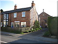
Chinnor Methodist Church
The church, which was built in 1872, is tucked away behind a couple of brick and flint cottages on Station Road, the right one of which certainly appears to be owned by the Church.
Image: © Nigel Cox
Taken: 30 Mar 2008
0.13 miles

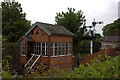
8
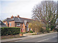
Former school, Chinnor
This large building on the junction of Oakley Road and Station Road was once a school. This view is from Oakley Road. The building is now converted into private apartments.
Image: © Richard Dorrell
Taken: 14 Mar 2012
0.13 miles
9
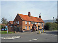
The Crown public house, Chinnor
Located at the junction between Station Road and Church Road. The Crown is one of several pubs in the village.
Image: © Richard Dorrell
Taken: 14 Mar 2012
0.13 miles