IMAGES TAKEN NEAR TO
Wharton Road, OXFORD, OX3 8AH
Introduction
This page details the photographs taken nearby to Wharton Road, OX3 8AH by members of the Geograph project.
The Geograph project started in 2005 with the aim of publishing, organising and preserving representative images for every square kilometre of Great Britain, Ireland and the Isle of Man.

There are currently over 7.5m images from over14,400 individuals and you can help contribute to the project by visiting https://www.geograph.org.uk
Image Map
Images are licensed for reuse under creativecommons.org/licenses/by-sa/2.0
Notes
- Clicking on the map will re-center to the selected point.
- The higher the marker number, the further away the image location is from the centre of the postcode.
Image Listing (52 Images Found)
Images are licensed for reuse under creativecommons.org/licenses/by-sa/2.0
Image
Details
Distance
1
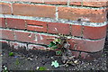
Benchmark on St Andrews CP School, London Road
Ordnance Survey cut mark benchmark described on the Bench Mark Database at http://www.bench-marks.org.uk/bm51653
Image: © Roger Templeman
Taken: 18 Sep 2013
0.07 miles
2
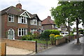
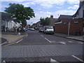
Houses on London Road
There is a milestone with an OS benchmark Image against the wall of #196
Image: © Roger Templeman
Taken: 18 Sep 2013
0.08 miles
3
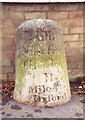
Old Milestone by the A420, London Road, Headington
Stokenchurch pillar by the A420, in parish of Oxford (Oxford District), London Road; Headington, by No.196, North of Bury Knowle Park, on path in front of low wall.
Inscription reads:-
LII
Miles from
London
II
Miles to
Oxford
Rivet benchmark on top.
Grade II listed.
List Entry Number: 1369694 https://historicengland.org.uk/listing/the-list/list-entry/1369694
Surveyed
Milestone Society National ID: OX_lw52
Image: © Milestone Society
Taken: Unknown
0.08 miles
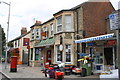
4
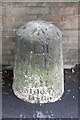
Milestone with benchmark outside #196 London Road
The milestone indicates LII (52) miles from London and II (2) miles to Oxford. It is shown on the 1880 1:2500 map of Oxfordshire. On top of the stone is an OS rivet benchmark which is described on the Bench Mark Database at http://www.bench-marks.org.uk/bm51483
Image: © Roger Templeman
Taken: 18 Sep 2013
0.08 miles
7
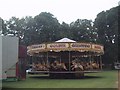
Fairground ride under construction in Bury Knowle Park, Headington
Image: © Sarah Charlesworth
Taken: 5 Jun 2009
0.11 miles
8
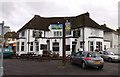
Headington Post Office and shops, London Road
There is an OS benchmark Image on the front corner of the Post Office left of the green wheelie bin
Image: © Roger Templeman
Taken: 18 Sep 2013
0.12 miles
9
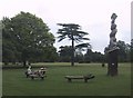
Benches in Bury Knowle Park, Headington
Image: © Sarah Charlesworth
Taken: 5 Jun 2009
0.13 miles
10
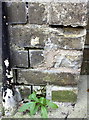
Damaged benchmark on Headington Post Office
Ordnance Survey cut mark benchmark described on the Bench Mark Database at http://www.bench-marks.org.uk/bm24417
Image: © Roger Templeman
Taken: 27 Sep 2013
0.13 miles