IMAGES TAKEN NEAR TO
High Street, OXFORD, OX33 1XU
Introduction
This page details the photographs taken nearby to High Street, OX33 1XU by members of the Geograph project.
The Geograph project started in 2005 with the aim of publishing, organising and preserving representative images for every square kilometre of Great Britain, Ireland and the Isle of Man.

There are currently over 7.5m images from over14,400 individuals and you can help contribute to the project by visiting https://www.geograph.org.uk
Image Map
Images are licensed for reuse under creativecommons.org/licenses/by-sa/2.0
Notes
- Clicking on the map will re-center to the selected point.
- The higher the marker number, the further away the image location is from the centre of the postcode.
Image Listing (163 Images Found)
Images are licensed for reuse under creativecommons.org/licenses/by-sa/2.0
Image
Details
Distance
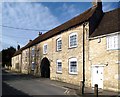
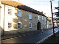
1
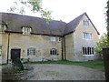
Wheatley Manor
Wheatley Manor house along High Street an Elizabethan which dates to medieval times
Image: © Bill Nicholls
Taken: 14 Oct 2015
0.04 miles
2
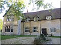
The Manor House
Wheatley Manor house along High Street an Elizabethan which dates to medieval times
Image: © Bill Nicholls
Taken: 14 Oct 2015
0.04 miles
3
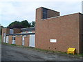
Wheatley Telephone Exchange, Oxon
Situated off Station Road, this redbrick TE has the code SMWLY, and provides telephone and broadband services to 2,967 residential and 146 non-residential premises in Wheatley plus Cuddesdon, Forest Hill, Holton, Horspath and Littleworth nearby. The railway line between Oxford and Princes Risborough used to pass near the site of this TE, but no trace can now be found of the track in Wheatley. Even the former station is now built on, although there is The Railway Inn adjacent to the TE. This TE has (01865) 87xxxx numbers, the (01865) referring to the Oxford group of twenty TEs, and its postcode is OX33 1ST.
Image: © David Hillas
Taken: 15 Sep 2010
0.06 miles
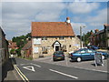
4
The Old George on High Street
The Old George is a former pub.
Image: © Steve Daniels
Taken: 22 Dec 2015
0.06 miles

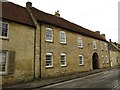
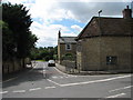
6
The Sun Inn, Wheatley, Oxfordshire
The road on the left is Church Road, that on the right is Westfield Road.
Image: © Roy Parkhouse
Taken: 25 Aug 2007
0.06 miles
7
Wheatley - High St, Littleworth Rd junction
Image: © Roy Parkhouse
Taken: 4 Jul 2007
0.06 miles
8
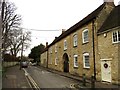
High Street in Wheatley
The building on the right is the former George Inn.
Image: © Steve Daniels
Taken: 22 Dec 2015
0.06 miles
9
The Old George
An old coaching inn very similar to The Old Crown on the other side of the village,
Image a reminder of Wheatley's former importance on the Oxford to London coaching route.
Image: © Des Blenkinsopp
Taken: 5 Mar 2014
0.07 miles
10
The George
The George along High Street Wheatley which looks to be a former coaching inn
Image: © Bill Nicholls
Taken: 14 Oct 2015
0.07 miles