IMAGES TAKEN NEAR TO
Jackies Lane, OXFORD, OX33 1UN
Introduction
This page details the photographs taken nearby to Jackies Lane, OX33 1UN by members of the Geograph project.
The Geograph project started in 2005 with the aim of publishing, organising and preserving representative images for every square kilometre of Great Britain, Ireland and the Isle of Man.

There are currently over 7.5m images from over14,400 individuals and you can help contribute to the project by visiting https://www.geograph.org.uk
Image Map
Images are licensed for reuse under creativecommons.org/licenses/by-sa/2.0
Notes
- Clicking on the map will re-center to the selected point.
- The higher the marker number, the further away the image location is from the centre of the postcode.
Image Listing (29 Images Found)
Images are licensed for reuse under creativecommons.org/licenses/by-sa/2.0
Image
Details
Distance
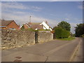
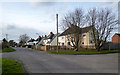
1

Jackson Lane, Wheatley
Houses beside the junction with Beech Road with the road (footpath) to Castle Hill Farm behind the photographer.
Image: © Andrew Smith
Taken: 23 Oct 2011
0.01 miles
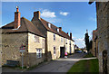
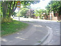
3
Beech Road, Wheatley
Away from the old village centre, the outer bits of Wheatley are much like loads of other places.
Image: © Des Blenkinsopp
Taken: 5 Mar 2014
0.07 miles
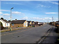
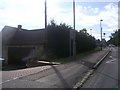
6
Corner of Ambrose Rise and London Road, Wheatley
Image: © David Howard
Taken: 25 Jul 2011
0.19 miles
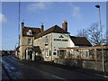
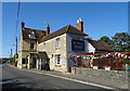
9
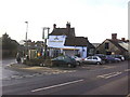
Kings Arms pub
Junction of London Road and Church Road.
Image: © Roger Templeman
Taken: 19 Jan 2011
0.21 miles