IMAGES TAKEN NEAR TO
Gidley Way, OXFORD, OX33 1TX
Introduction
This page details the photographs taken nearby to Gidley Way, OX33 1TX by members of the Geograph project.
The Geograph project started in 2005 with the aim of publishing, organising and preserving representative images for every square kilometre of Great Britain, Ireland and the Isle of Man.

There are currently over 7.5m images from over14,400 individuals and you can help contribute to the project by visiting https://www.geograph.org.uk
Image Map
Images are licensed for reuse under creativecommons.org/licenses/by-sa/2.0
Notes
- Clicking on the map will re-center to the selected point.
- The higher the marker number, the further away the image location is from the centre of the postcode.
Image Listing (9 Images Found)
Images are licensed for reuse under creativecommons.org/licenses/by-sa/2.0
Image
Details
Distance
1
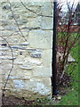
Benchmark on Ways Farm barn conversion
Ordnance Survey cut mark benchmark described on the Bench Mark Database at http://www.bench-marks.org.uk/bm36602
Image: © Roger Templeman
Taken: 27 Jan 2011
0.05 miles
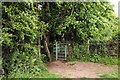
4
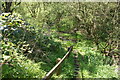
Footpath crossing the old railway track
The path crosses a cutting and the ground is soft and damp at the bottom. The railway ran between Oxford and Thame.
Image: © Bill Boaden
Taken: 3 May 2014
0.19 miles
5
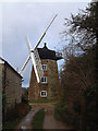
The Octagonal Windmill at Wheatley
At Windmill Lane, Wheatley. Owned by the Cripps family for 150 years. Restored 2007 : http://www.wheatleymill.co.uk/ . Only the top of a tower mill revolves. The tower, being made of stone, means the windmill is less likely to be damaged by fire.
Image: © Roy Parkhouse
Taken: 9 Dec 2007
0.21 miles
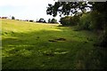
6
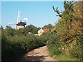
Windmill Lane, Wheatley
For some reason Windmill Lane degenerates into a track for a few hundred metres between two surfaced sections.
The windmill is quite attractive but hard to do justice to in a picture due to all the foliage around it.
Image: © Des Blenkinsopp
Taken: 5 Sep 2012
0.22 miles
8

Events at the Cricketers Arms and a benchmark
The Ordnance Survey cut mark benchmark is described on the Bench Mark Database at http://www.bench-marks.org.uk/bm36618
Image: © Roger Templeman
Taken: 27 Jan 2011
0.25 miles
9
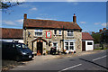
Cricketers Arms, Littleworth
Excellent village pub which is part of the community. It stocks several good local beers.
Image: © Bill Boaden
Taken: 3 May 2014
0.25 miles