IMAGES TAKEN NEAR TO
Sandy Lane, OXFORD, OX33 1TF
Introduction
This page details the photographs taken nearby to Sandy Lane, OX33 1TF by members of the Geograph project.
The Geograph project started in 2005 with the aim of publishing, organising and preserving representative images for every square kilometre of Great Britain, Ireland and the Isle of Man.

There are currently over 7.5m images from over14,400 individuals and you can help contribute to the project by visiting https://www.geograph.org.uk
Image Map
Images are licensed for reuse under creativecommons.org/licenses/by-sa/2.0
Notes
- Clicking on the map will re-center to the selected point.
- The higher the marker number, the further away the image location is from the centre of the postcode.
Image Listing (6 Images Found)
Images are licensed for reuse under creativecommons.org/licenses/by-sa/2.0
Image
Details
Distance
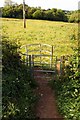
3
Blenheim Road by Horspath Common
Horspath Common is part of Shotover Country Park. The track connects Horspath to Old Road.
Image: © Steve Daniels
Taken: 20 Mar 2018
0.23 miles

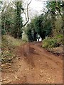
5
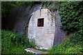
The bricked up west portal of Horspath Tunnel
The former railway tunnel has been bricked up and is now a sanctuary for bats. The Princes Risborough to Oxford Railway ran through the tunnel until 1963. The tunnel is 520 yards long under a clay hill and is completely lined throughout.
Image: © Steve Daniels
Taken: 25 May 2011
0.24 miles