IMAGES TAKEN NEAR TO
Collcutt Close, OXFORD, OX33 1RS
Introduction
This page details the photographs taken nearby to Collcutt Close, OX33 1RS by members of the Geograph project.
The Geograph project started in 2005 with the aim of publishing, organising and preserving representative images for every square kilometre of Great Britain, Ireland and the Isle of Man.

There are currently over 7.5m images from over14,400 individuals and you can help contribute to the project by visiting https://www.geograph.org.uk
Image Map
Images are licensed for reuse under creativecommons.org/licenses/by-sa/2.0
Notes
- Clicking on the map will re-center to the selected point.
- The higher the marker number, the further away the image location is from the centre of the postcode.
Image Listing (49 Images Found)
Images are licensed for reuse under creativecommons.org/licenses/by-sa/2.0
Image
Details
Distance
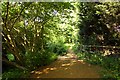
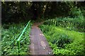
1
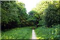
Footpath in the Horspath Parish Council Wildlife Conservation Area
The Nature Reserve is in the tunnel cutting of the former Princes Risborough to Oxford railway.
Image: © Steve Daniels
Taken: 25 May 2011
0.03 miles
2
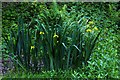
Yellow flags in the former railway cutting
The Nature Reserve is in the tunnel cutting of the former Princes Risborough to Oxford railway.
Image: © Steve Daniels
Taken: 25 May 2011
0.04 miles
3
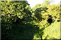
The former track bed of the Princes Risborough to Oxford Railway
The former Princes Risborough to Oxford railway was closed in 1963.
Image: © Steve Daniels
Taken: 25 May 2011
0.04 miles
4
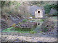
Horspath: Disused railway tunnel portal
This is the western portal of the Horspath Tunnel which formerly carried the Oxford to Princes Risborough railway line through the eastern end of Shotover Hill. The tunnel was (and still is) 475 metres (520 yards) long. The railway was closed in 1963, and the abandoned tunnel subsequently proved a popular venue for illegal raves in the 1980s and 1990s, as well as a popular roost for bats. However in 2002 the tunnel was taken over by Oxfordshire County Council, and formally turned into a bat hibernaculum, or winter hibernating refuge. Five species of bats, Daubenton’s, Brown Long-Eared, Natterer’s, Brandt’s, and Whiskered, are said to use the tunnel. This transformation was achieved with major financial assistance from the Esmée Fairbairn Foundation http://www.esmeefairbairn.org.uk/ and One World Wildlife (formerly The Biodiversity Trust).
The former trackbed immediately outside the tunnel is maintained as a Wildlife Conservation Area by Horspath Parish Council http://home.clara.net/shotover/horspath/hiber.htm and a volunteer member is hard at work.
(Mrs Albion was forcibly reminded of Henry the Green Engine with this image!)
Image: © Nigel Cox
Taken: 16 Jan 2008
0.06 miles
5
Footpath in the Horspath Parish Council Wildlife Conservation Area
Image: © Steve Daniels
Taken: 25 May 2011
0.06 miles
6
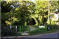
Kissing gate to the Horspath Parish Council Wildlife Conservation Area
Image: © Steve Daniels
Taken: 25 May 2011
0.06 miles
7
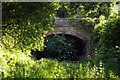
Butts Road crosses the former railway
The former Princes Risborough to Oxford railway was closed in 1963.
Image: © Steve Daniels
Taken: 25 May 2011
0.07 miles
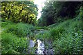
8
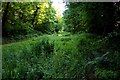
Boggy wetland in the former railway cutting
The Nature Reserve is in the tunnel cutting of the former Princes Risborough to Oxford railway.
Image: © Steve Daniels
Taken: 25 May 2011
0.07 miles
10
Boggy wetland in the former railway cutting
The Nature Reserve is in the tunnel cutting of the former Princes Risborough to Oxford railway.
Image: © Steve Daniels
Taken: 25 May 2011
0.07 miles