IMAGES TAKEN NEAR TO
Wrightson Close, OXFORD, OX33 1RR
Introduction
This page details the photographs taken nearby to Wrightson Close, OX33 1RR by members of the Geograph project.
The Geograph project started in 2005 with the aim of publishing, organising and preserving representative images for every square kilometre of Great Britain, Ireland and the Isle of Man.

There are currently over 7.5m images from over14,400 individuals and you can help contribute to the project by visiting https://www.geograph.org.uk
Image Map
Images are licensed for reuse under creativecommons.org/licenses/by-sa/2.0
Notes
- Clicking on the map will re-center to the selected point.
- The higher the marker number, the further away the image location is from the centre of the postcode.
Image Listing (79 Images Found)
Images are licensed for reuse under creativecommons.org/licenses/by-sa/2.0
Image
Details
Distance
1
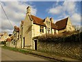
Horspath Manor on Church Road
Parts of the Manor House date back to the 16th Century.
Image: © Steve Daniels
Taken: 20 Mar 2018
0.04 miles
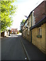
2
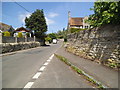
Church Road north
The view in Horspath village Oxfordshire.
Image: © Gordon Griffiths
Taken: 1 Jun 2013
0.04 miles
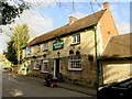
5
The Queen's Head
The view of the Pub in Church Road in Horspath Village.
Image: © Gordon Griffiths
Taken: 1 Jun 2013
0.06 miles
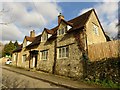
6
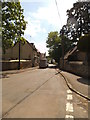
Church Road south
The view in Horspath village Oxfordshire.
Image: © Gordon Griffiths
Taken: 1 Jun 2013
0.06 miles
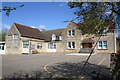
7
Benchmark on CE Primary School
Ordnance Survey cut mark benchmark described on the Bench Mark Data base at http://www.bench-marks.org.uk/bm56497
Image: © Roger Templeman
Taken: 10 Apr 2014
0.07 miles
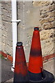
8
Horspath CE Primary School
There is an OS benchmark Image on the side of the school by the red cones at the right hand edge of the image
Image: © Roger Templeman
Taken: 10 Apr 2014
0.08 miles
9
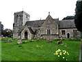
St Giles' Church, Horspath
The earliest parts of the church date from C12. The tower was added around 1400.
The spelling "Horspath" was adopted in 1912. Earlier it had been "Horsepadan" and then "Horsepath".
Image: © Bikeboy
Taken: 7 Apr 2014
0.08 miles
10
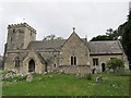
St Giles Church, Horspath
The church is built of stone and comprises a nave, chancel, south aisle, north and south transepts or chapels, west tower, and south porch, and stands in the northern part of the village in a large churchyard. The nave was probably built in the late 12th century and the south transept was added in the late 13th century. The embattled tower, with a west doorway and a three-light west window, was probably added about 1400.
Image: © Richard Rogerson
Taken: 28 Apr 2011
0.09 miles