IMAGES TAKEN NEAR TO
Blenheim Lane, OXFORD, OX33 1NJ
Introduction
This page details the photographs taken nearby to Blenheim Lane, OX33 1NJ by members of the Geograph project.
The Geograph project started in 2005 with the aim of publishing, organising and preserving representative images for every square kilometre of Great Britain, Ireland and the Isle of Man.

There are currently over 7.5m images from over14,400 individuals and you can help contribute to the project by visiting https://www.geograph.org.uk
Image Map
Images are licensed for reuse under creativecommons.org/licenses/by-sa/2.0
Notes
- Clicking on the map will re-center to the selected point.
- The higher the marker number, the further away the image location is from the centre of the postcode.
Image Listing (96 Images Found)
Images are licensed for reuse under creativecommons.org/licenses/by-sa/2.0
Image
Details
Distance
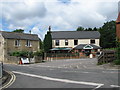
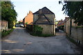
3
New Club on the Left
View out of High Street Wheatley to the end of Church Lane with the New Club social club to the left
Image: © Bill Nicholls
Taken: 14 Oct 2015
0.03 miles
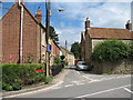
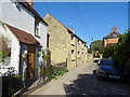
7
The junction of Kiln Lane and Westfield Road
An older part of Wheatley.
Image: © Bill Boaden
Taken: 3 May 2014
0.06 miles
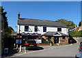
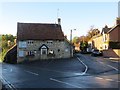
8
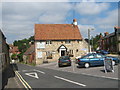
The Sun Inn, Wheatley, Oxfordshire
The road on the left is Church Road, that on the right is Westfield Road.
Image: © Roy Parkhouse
Taken: 25 Aug 2007
0.06 miles

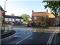
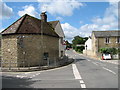
10
Sun on the Corner
The Sun public house on the corner of Westfield and Church Road in Wheatley
Image: © Bill Nicholls
Taken: 14 Oct 2015
0.07 miles