IMAGES TAKEN NEAR TO
Worminghall Road, OXFORD, OX33 1LF
Introduction
This page details the photographs taken nearby to Worminghall Road, OX33 1LF by members of the Geograph project.
The Geograph project started in 2005 with the aim of publishing, organising and preserving representative images for every square kilometre of Great Britain, Ireland and the Isle of Man.

There are currently over 7.5m images from over14,400 individuals and you can help contribute to the project by visiting https://www.geograph.org.uk
Image Map
Images are licensed for reuse under creativecommons.org/licenses/by-sa/2.0
Notes
- Clicking on the map will re-center to the selected point.
- The higher the marker number, the further away the image location is from the centre of the postcode.
Image Listing (15 Images Found)
Images are licensed for reuse under creativecommons.org/licenses/by-sa/2.0
Image
Details
Distance

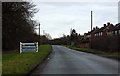
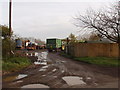
2
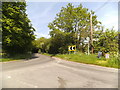
Oxfordshire Junction
The junction near Waterperry for Wheatley and Common Leys Farm.
Image: © Gordon Griffiths
Taken: 2 Jun 2013
0.08 miles
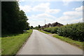
3
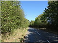
National Cycle Route 57
Towards Worminghall.
Image: © JThomas
Taken: 21 Sep 2019
0.08 miles
4
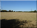
Parched grazing off National Cycle Route 57
Image: © JThomas
Taken: 21 Sep 2019
0.09 miles
5
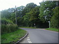
Junction of road from Waterperry village
Image: © David Howard
Taken: 25 Jul 2011
0.09 miles
8
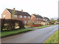
Houses in Waterperry
On the road to Waterperry gardens.
Image: © David Hawgood
Taken: 28 Nov 2008
0.15 miles
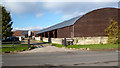
10
Farmyard in Waterperry
View from road.
Image: © David Hawgood
Taken: 28 Nov 2008
0.18 miles