IMAGES TAKEN NEAR TO
Waterstock, OXFORD, OX33 1JS
Introduction
This page details the photographs taken nearby to OX33 1JS by members of the Geograph project.
The Geograph project started in 2005 with the aim of publishing, organising and preserving representative images for every square kilometre of Great Britain, Ireland and the Isle of Man.

There are currently over 7.5m images from over14,400 individuals and you can help contribute to the project by visiting https://www.geograph.org.uk
Image Map
Images are licensed for reuse under creativecommons.org/licenses/by-sa/2.0
Notes
- Clicking on the map will re-center to the selected point.
- The higher the marker number, the further away the image location is from the centre of the postcode.
Image Listing (33 Images Found)
Images are licensed for reuse under creativecommons.org/licenses/by-sa/2.0
Image
Details
Distance
1
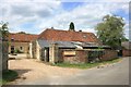
Waterstock Training Centre
A riding school based in the stables at Waterstock House.
Image: © Des Blenkinsopp
Taken: 24 Jun 2015
0.03 miles
2
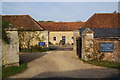
Waterstock House Training Centre
It gives training in equestrianism.
Image: © Bill Boaden
Taken: 23 Oct 2011
0.04 miles
3
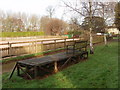
Grandstand by training ring
Coming from the church, this minimal grandstand appears to be in the churchyard. It gives a view to Waterstock Training Centre rubber and fibre sand surface manege.
Image: © David Hawgood
Taken: 28 Nov 2008
0.04 miles
4
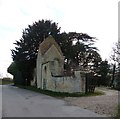
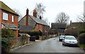
Rhenish-helm roofed pump house, Waterstock
This little building incorporated into the gate wall of Waterstock House used to be a pump house. It has a very distinctive "rhenish-helm" roof, which is unusual in Britain. Though it looks older, the EH listing https://historicengland.org.uk/listing/the-list/list-entry/1047558 states that it dates from 1898. The gateway is the entrance to Waterstock House which dates from the C18th (see Bill Boaden's photo here Image])
Image: © Rob Farrow
Taken: 15 Feb 2014
0.05 miles
6
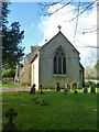
Waterstock church - east end
St. Leonard's is late 15th century, a grade II*(star) listed building.
Image: © Robin Webster
Taken: 22 Feb 2014
0.07 miles
7
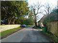
Lane by Waterstock church
The church is on the left.
Image: © Robin Webster
Taken: 22 Feb 2014
0.07 miles
8
Waterstock church
St. Leonard's is late 15th century, a grade II*(star) listed building.
Image: © Robin Webster
Taken: 22 Feb 2014
0.07 miles
9
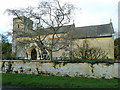
Waterstock church
St. Leonard's. Not easy to photograph as beset by trees and bushes. Fortunately the near tree is fairly transparent in the winter.
Image: © Robin Webster
Taken: 22 Feb 2014
0.07 miles
10
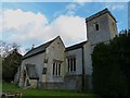
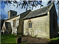
St Leonard's from track on northern side
The church of St Leonard is aligned somewhat out of true from the usual East-West orientation, so that although this is the "northern" side it is actually facing nearer to northeast. This photo was taken from the track which separates the northern side of the church from the estate of Waterstock House.
See shared description of the church below.
Image: © Rob Farrow
Taken: 15 Feb 2014
0.07 miles