IMAGES TAKEN NEAR TO
London Road, OXFORD, OX33 1JL
Introduction
This page details the photographs taken nearby to London Road, OX33 1JL by members of the Geograph project.
The Geograph project started in 2005 with the aim of publishing, organising and preserving representative images for every square kilometre of Great Britain, Ireland and the Isle of Man.

There are currently over 7.5m images from over14,400 individuals and you can help contribute to the project by visiting https://www.geograph.org.uk
Image Map
Images are licensed for reuse under creativecommons.org/licenses/by-sa/2.0
Notes
- Clicking on the map will re-center to the selected point.
- The higher the marker number, the further away the image location is from the centre of the postcode.
Image Listing (27 Images Found)
Images are licensed for reuse under creativecommons.org/licenses/by-sa/2.0
Image
Details
Distance
2
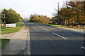
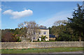
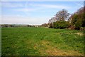
London Road
London Road heading out of Wheatley to the A40
Image: © Shaun Ferguson
Taken: 4 Nov 2007
0.04 miles
3
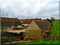
Converted farm buildings
Used for small businesses.
Image: © Bikeboy
Taken: 7 Apr 2014
0.07 miles
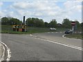
6
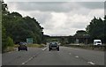
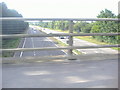
A418 bridge, A40/M40 junction
The small A40 route confirmatory sign in the central reservation is very prompt indeed. The motorway technically ends at the slip road's entry ahead.
Image: © Peter Whatley
Taken: 12 Apr 2011
0.14 miles
7
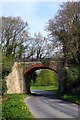
Former railway bridge over Sworford Lane
The bridge used to carry the line from Princes Risborough to Kennington Junction. It was closed in 1963.
Image: © Steve Daniels
Taken: 11 Apr 2011
0.14 miles
8
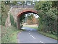
Former Railway Bridge, Wheatley, Oxfordshire
Bridge which carried the Oxford to Thame railway line across the Great Milton to Wheatley road (Sworford Lane).
Image: © Anthony Brunning
Taken: 26 Oct 2005
0.14 miles
10
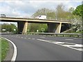
Access to the A40 south of Wheatley
The tightness of this junction at the point of transition between the original M40 Oxford route and the A40 is readily apparent. The junction is technically in trumpet style, but with a hugely restricted land take on its western side to permit access to Wheatley along what was once the A40. The curvature of the western slip roads is similar to that on the M50 at junction 3 (http://www.geograph.org.uk/photo/2044290). Both were devised in the early days of UK motorway construction when standards were considerably lower than today.
Image: © Peter Whatley
Taken: 12 Apr 2011
0.17 miles