IMAGES TAKEN NEAR TO
Pound Lane, OXFORD, OX33 1HF
Introduction
This page details the photographs taken nearby to Pound Lane, OX33 1HF by members of the Geograph project.
The Geograph project started in 2005 with the aim of publishing, organising and preserving representative images for every square kilometre of Great Britain, Ireland and the Isle of Man.

There are currently over 7.5m images from over14,400 individuals and you can help contribute to the project by visiting https://www.geograph.org.uk
Image Map
Images are licensed for reuse under creativecommons.org/licenses/by-sa/2.0
Notes
- Clicking on the map will re-center to the selected point.
- The higher the marker number, the further away the image location is from the centre of the postcode.
Image Listing (90 Images Found)
Images are licensed for reuse under creativecommons.org/licenses/by-sa/2.0
Image
Details
Distance
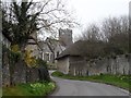
1
Postal delivery in Pound Lane
The Royal Mail van stops at a house on Pound Lane.
Image: © Stephen Craven
Taken: 24 Mar 2010
0.01 miles
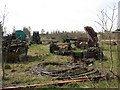
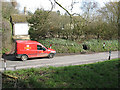
4
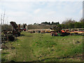
Farm machinery at Rectory Farm (1)
Miscellaneous agricultural machinery, visible from the side of Pound Lane.
Image: © Stephen Craven
Taken: 24 Mar 2010
0.05 miles
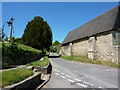
5
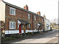
Houses on Pound Lane
These houses on the northern limit of Stanton St John village would probably have been built for agricultural workers.
Image: © Stephen Craven
Taken: 24 Mar 2010
0.06 miles
6

Church Close, off Pound Lane
This modern housing development is next to the churchyard and the name suggests that it was built on church land.
Image: © Stephen Craven
Taken: 24 Mar 2010
0.06 miles
7

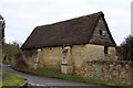
War memorial, Stanton St John
In the church yard of St John the Baptist. The building behind is a C17/C18 stable. See http://www.britishlistedbuildings.co.uk/en-246690-stables-approximately-40-metres-south-of for entry in British Listed Buildings.
Image: © Bikeboy
Taken: 22 Mar 2015
0.06 miles
9
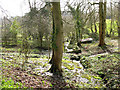
Springs in the grounds of Stanton House
A group of springs is shown on the 1:25,000 map of which a few are shown here. According to a local guidebook they mark the geological boundary between the impervious Oxford Clay and the overlying Corallian Limestone. The water is channelled into the ornamental ponds shown in Image and eventually becomes the mill stream.
Image: © Stephen Craven
Taken: 24 Mar 2010
0.07 miles