IMAGES TAKEN NEAR TO
Milton Common, OXFORD, OX33 1GX
Introduction
This page details the photographs taken nearby to OX33 1GX by members of the Geograph project.
The Geograph project started in 2005 with the aim of publishing, organising and preserving representative images for every square kilometre of Great Britain, Ireland and the Isle of Man.

There are currently over 7.5m images from over14,400 individuals and you can help contribute to the project by visiting https://www.geograph.org.uk
Image Map
Images are licensed for reuse under creativecommons.org/licenses/by-sa/2.0
Notes
- Clicking on the map will re-center to the selected point.
- The higher the marker number, the further away the image location is from the centre of the postcode.
Image Listing (9 Images Found)
Images are licensed for reuse under creativecommons.org/licenses/by-sa/2.0
Image
Details
Distance
1
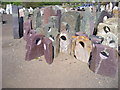
Ornamental Stone Yard
Any size, any shape, any colour...
Image: © john shortland
Taken: 21 Apr 2009
0.05 miles


6
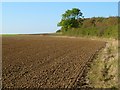
Farmland, Great Milton
Arable land to the south of the M40.
Image: © Andrew Smith
Taken: 15 Oct 2011
0.16 miles
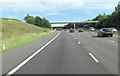
7
M40 near Wheatley
Northbound, approaching Junction 8A
Image: © MrC
Taken: 13 Oct 2012
0.17 miles
8

M40 southbound entry slip at Junction 8A
Image: © Colin Pyle
Taken: 26 Feb 2012
0.18 miles
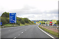
9

Northbound M40 Approaching Oxford Service Area (Junction 8A)
Image: © David Dixon
Taken: 17 May 2013
0.18 miles