IMAGES TAKEN NEAR TO
Wheatley Road, OXFORD, OX33 1EW
Introduction
This page details the photographs taken nearby to Wheatley Road, OX33 1EW by members of the Geograph project.
The Geograph project started in 2005 with the aim of publishing, organising and preserving representative images for every square kilometre of Great Britain, Ireland and the Isle of Man.

There are currently over 7.5m images from over14,400 individuals and you can help contribute to the project by visiting https://www.geograph.org.uk
Image Map
Images are licensed for reuse under creativecommons.org/licenses/by-sa/2.0
Notes
- Clicking on the map will re-center to the selected point.
- The higher the marker number, the further away the image location is from the centre of the postcode.
Image Listing (39 Images Found)
Images are licensed for reuse under creativecommons.org/licenses/by-sa/2.0
Image
Details
Distance
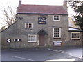
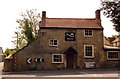
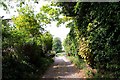
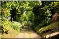
8
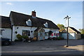
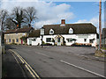
The White Horse, Forest Hill
An outlet for Goldfinch beers, but it wasn't open.
Image: © Bill Boaden
Taken: 3 May 2014
0.17 miles
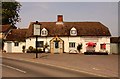
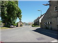
10
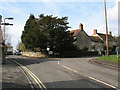
Road junction in Forest Hill
The B-road through the village takes in a double bend, here turning right towards Stanton St John.
Image: © Stephen Craven
Taken: 25 Mar 2010
0.17 miles