IMAGES TAKEN NEAR TO
Wheatley Road, OXFORD, OX33 1ET
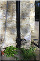
Introduction
This page details the photographs taken nearby to Wheatley Road, OX33 1ET by members of the Geograph project.
The Geograph project started in 2005 with the aim of publishing, organising and preserving representative images for every square kilometre of Great Britain, Ireland and the Isle of Man.

There are currently over 7.5m images from over14,400 individuals and you can help contribute to the project by visiting https://www.geograph.org.uk
Image Map
Images are licensed for reuse under creativecommons.org/licenses/by-sa/2.0
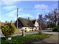
Notes
- Clicking on the map will re-center to the selected point.
- The higher the marker number, the further away the image location is from the centre of the postcode.
Image Listing (40 Images Found)
Images are licensed for reuse under creativecommons.org/licenses/by-sa/2.0
Image
Details
Distance
1
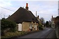
The Holford Centre
The village school in Stanton St John closed in 1984 (according to a local history booklet) and is now the Holford Centre. The road to it is still called School Lane.
Image: © Stephen Craven
Taken: 25 Mar 2010
0.01 miles
2
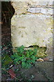
Benchmark on The Holford Centre
Ordnance Survey cut mark levelled at 106.341m above Newlyn Datum
Image: © Roger Templeman
Taken: 25 Feb 2019
0.01 miles
3
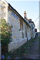
The Holford Centre, School Lane
There is an OS benchmark Image on the near corner, right hand face, of the former primary school
Image: © Roger Templeman
Taken: 25 Feb 2019
0.02 miles
4
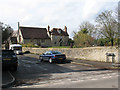
Talk House - Stanton St John
pub restaurant on the Islip Wheatley road; formerly the George
Image: © al partington
Taken: 15 Feb 2006
0.04 miles
5

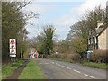
Rusty bus stop
This bus stop sign on the B4027 in Stanton St John was so rusty it looked disused, though there was a current timetable on it.
Image: © Stephen Craven
Taken: 25 Mar 2010
0.04 miles
6
Benchmark on The Talk House
Ordnance Survey cut mark benchmark levelled at 106.344m above Newlyn Datum
Image: © Roger Templeman
Taken: 25 Feb 2019
0.04 miles
7
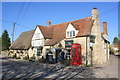
The Talk House at Wheatley Road / Middle Road junction
The pub was previously The George. There is an OS benchmark Image on the near corner, left hand face of the building
Image: © Roger Templeman
Taken: 25 Feb 2019
0.05 miles
8
Stanton St John - warning signs for drivers
Just inside the 30mph limit, entering the village on the B4027 from the south, is a set of signs warning of children, side roads and a sharp right-hand bend (the latter is misleading since the road is virtually straight with only gentle bends for the next 2km).
Image: © Stephen Craven
Taken: 25 Mar 2010
0.05 miles
9
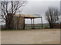
Dutch barn, Stanton St John
View from road across car park of the Talk House pub - which was empty, although that of the Star was busy.
Image: © David Hawgood
Taken: 28 Nov 2008
0.06 miles