IMAGES TAKEN NEAR TO
Stanton Road, OXFORD, OX33 1DT
Introduction
This page details the photographs taken nearby to Stanton Road, OX33 1DT by members of the Geograph project.
The Geograph project started in 2005 with the aim of publishing, organising and preserving representative images for every square kilometre of Great Britain, Ireland and the Isle of Man.

There are currently over 7.5m images from over14,400 individuals and you can help contribute to the project by visiting https://www.geograph.org.uk
Image Map
Images are licensed for reuse under creativecommons.org/licenses/by-sa/2.0
Notes
- Clicking on the map will re-center to the selected point.
- The higher the marker number, the further away the image location is from the centre of the postcode.
Image Listing (42 Images Found)
Images are licensed for reuse under creativecommons.org/licenses/by-sa/2.0
Image
Details
Distance
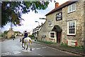
1
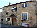
The White Horse, Forest Hill
White Horse Inn, Forest Hill.
Image: © Bill Johnson
Taken: 13 Dec 2007
0.05 miles
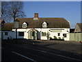
2
White Horse - Forest Hill
Former Morrells brewery pub
Image: © al partington
Taken: 15 Feb 2006
0.05 miles
3
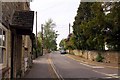
High Street, Forest Hill
A view looking into the High Street from the junction with the B4027 as it passes through the centre of the village.
Image: © Bill Johnson
Taken: 13 Dec 2007
0.05 miles
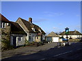
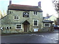
4
Riding Past The Kings Arms
An old pub at the junction of Main Street with Stanton Road. The pub is now a house but the old pub sign has been kept, showing it was one of the 300 pubs in the Hall's Oxford Brewery estate.
Thanks to the Brewery history society for this info on Hall's - "Registered in December 1896 to acquire Hall & Co. From April 1899 all brewing was concentrated at the City Brewery.
Acquired with 300 tied houses by Allsopp & Sons Ltd in 1926 and brewing ceased.
The Hall's brand was retained for many years afterwards, and many of their houses featured four wall-mounted tiles with the 'Hare' trade mark" .http://breweryhistory.com/wiki/index.php?title=Hall%27s_Oxford_Brewery_Ltd
Company accounts were last registered in 2002 so it looks like even the pubco. business has ceased and Hall's really is history.
Image: © Des Blenkinsopp
Taken: 3 Feb 2020
0.06 miles
5
The King's Arms
Former pub, now a private residence, at the junction of Wheatley Road/Main Street and Stanton Road. Old Maps and Ordnance Survey records indicate a benchmark on the front of the building: a possible cut mark benchmark Image was found left of the right hand post of the sharp bend sign
Image: © Roger Templeman
Taken: 19 Jan 2011
0.06 miles
6
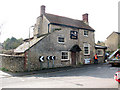
The Kings Arms, Forest Hill
I was unsure whether the pub was still open, as the inn sign had been removed but no windows were boarded up.
Image: © Stephen Craven
Taken: 25 Mar 2010
0.06 miles
7
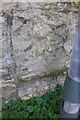
Possible benchmark on The Kings Arms
Ordnance Survey records indicate a cut mark benchmark on the front of the building levelled at 100.411m above Newlyn Datum.
Image: © Roger Templeman
Taken: 25 Feb 2019
0.07 miles
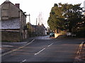
9
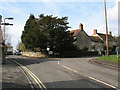
Road junction in Forest Hill
The B-road through the village takes in a double bend, here turning right towards Stanton St John.
Image: © Stephen Craven
Taken: 25 Mar 2010
0.07 miles