IMAGES TAKEN NEAR TO
Horton-cum-Studley, OXFORD, OX33 1DA
Introduction
This page details the photographs taken nearby to OX33 1DA by members of the Geograph project.
The Geograph project started in 2005 with the aim of publishing, organising and preserving representative images for every square kilometre of Great Britain, Ireland and the Isle of Man.

There are currently over 7.5m images from over14,400 individuals and you can help contribute to the project by visiting https://www.geograph.org.uk
Image Map
Images are licensed for reuse under creativecommons.org/licenses/by-sa/2.0
Notes
- Clicking on the map will re-center to the selected point.
- The higher the marker number, the further away the image location is from the centre of the postcode.
Image Listing (8 Images Found)
Images are licensed for reuse under creativecommons.org/licenses/by-sa/2.0
Image
Details
Distance
1
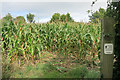
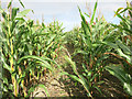
Entering the Maize
Please keep to the footpath, says the sign.
Not much chance of wandering off in this lot....
The way through is clear (ish) but you can't see where you are till you get to the other side of the field.
Image: © Des Blenkinsopp
Taken: 28 Sep 2016
0.04 miles

3
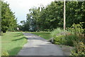
Warren Farm, Horton-cum-Studley
View from inside the entrance to teaching farm looking towards road.
Image: © Jackie Harman
Taken: 13 Aug 2006
0.07 miles
4
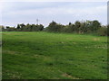
Footpath to Old Arngrove farm
Footpath to Old Arngrove farm from Warren farm drive
Image: © Shaun Ferguson
Taken: 28 Sep 2008
0.08 miles
6
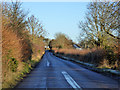
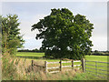
Brill Road
Heading away from Horton-cum-Studley towards several other places as well as Brill.
Image: © Robin Webster
Taken: 4 Dec 2016
0.11 miles

8
A Maize Maze?
Public footpath at Warren Farm.
Pretty much the same place as this Image believe it or not.
Image: © Des Blenkinsopp
Taken: 28 Sep 2016
0.11 miles