IMAGES TAKEN NEAR TO
Horton-cum-Studley, OXFORD, OX33 1BS
Introduction
This page details the photographs taken nearby to OX33 1BS by members of the Geograph project.
The Geograph project started in 2005 with the aim of publishing, organising and preserving representative images for every square kilometre of Great Britain, Ireland and the Isle of Man.

There are currently over 7.5m images from over14,400 individuals and you can help contribute to the project by visiting https://www.geograph.org.uk
Image Map
Images are licensed for reuse under creativecommons.org/licenses/by-sa/2.0
Notes
- Clicking on the map will re-center to the selected point.
- The higher the marker number, the further away the image location is from the centre of the postcode.
Image Listing (3 Images Found)
Images are licensed for reuse under creativecommons.org/licenses/by-sa/2.0
Image
Details
Distance
1
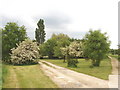
Trees at Gardener's Barn, Horton-cum-Studley
The barn has been converted into a house. A variety of english native trees have been planted on a grassy area in front. I noticed oak, ash and poplar as well as the hawthorns seen here in flower.
Image: © David Hawgood
Taken: 1 Jun 2006
0.09 miles
2
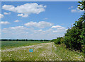
Conservation along the edge
A long strip of wild flowers runs along the field boundary. Conservation Area No Access says the notice.
Image: © Des Blenkinsopp
Taken: 1 Jun 2020
0.17 miles
3
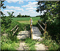
Two Bridges for the Footpath
A new bridge has been put over a small stream, but they've left the old one, maybe because there's not all that much wrong with it.
Image: © Des Blenkinsopp
Taken: 1 Jun 2020
0.18 miles