IMAGES TAKEN NEAR TO
Horton-cum-Studley, OXFORD, OX33 1BA
Introduction
This page details the photographs taken nearby to OX33 1BA by members of the Geograph project.
The Geograph project started in 2005 with the aim of publishing, organising and preserving representative images for every square kilometre of Great Britain, Ireland and the Isle of Man.

There are currently over 7.5m images from over14,400 individuals and you can help contribute to the project by visiting https://www.geograph.org.uk
Image Map
Images are licensed for reuse under creativecommons.org/licenses/by-sa/2.0
Notes
- Clicking on the map will re-center to the selected point.
- The higher the marker number, the further away the image location is from the centre of the postcode.
Image Listing (10 Images Found)
Images are licensed for reuse under creativecommons.org/licenses/by-sa/2.0
Image
Details
Distance
1
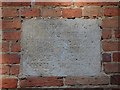
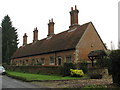
Plaque on Studley Almshouses
The Almshouses were built in 1639. See http://www.geograph.org.uk/photo/4405372 for a view of the almshouses.
Image: © Bikeboy
Taken: 22 Mar 2015
0.00 miles
2
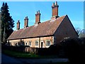
Studley Almshouses
Built in 1639 for Sir George Croke. See http://www.geograph.org.uk/photo/4405381 for a close-up of the plaque on the wall.
Image: © Bikeboy
Taken: 22 Mar 2015
0.01 miles
4
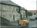
Almshouses on Horton hill
A row of Almshouses on Horton hill
Image: © Shaun Ferguson
Taken: 28 Sep 2008
0.05 miles
6
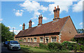
Studley Almshouses
Built in 1639 for Sir George Croke. In 1631 he left money in his will to provide housing for 'four men of over 60 and four women of over 50'.
House rules included no drunkenness or swearing.
https://historicengland.org.uk/services-skills/education/educational-images/studley-almshouses-horton-cum-studley-7585
Image: © Des Blenkinsopp
Taken: 1 Jun 2020
0.08 miles
7
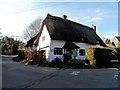
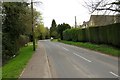
Corner Cottage, Horton Cum Studley
Late C16/early C17 farmhouse. See http://www.britishlistedbuildings.co.uk/en-243294-corner-cottage-horton-cum-studley-oxford for entry in British Listed Buildings
Image: © Bikeboy
Taken: 22 Mar 2015
0.13 miles
8
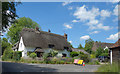
Diversion at Cobweb Cottage
A lovely old thatched cottage with a sort of flying dog on the roof.
Image: © Des Blenkinsopp
Taken: 1 Jun 2020
0.13 miles
10
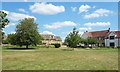
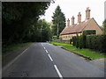
Village Green, Horton-cum-Studley
As the name suggests, this long village is a merger of two formerly separate parishes. This is Horton, at the bottom of the hill, which has always been in Oxfordshire. Studley, at the top of the hill, was once partly in Buckinghamshire and partly in Oxon. The merger of the two villages involved the Counties (Detached Parts) Act of 1844. A full history is on https://en.wikipedia.org/wiki/Horton-cum-Studley
The village is one of the "seven towns of Otmoor" along with the other six villages around the edge of the moor.
Image: © Des Blenkinsopp
Taken: 1 Jun 2020
0.24 miles