IMAGES TAKEN NEAR TO
Ventfield Close, OXFORD, OX33 1AN
Introduction
This page details the photographs taken nearby to Ventfield Close, OX33 1AN by members of the Geograph project.
The Geograph project started in 2005 with the aim of publishing, organising and preserving representative images for every square kilometre of Great Britain, Ireland and the Isle of Man.

There are currently over 7.5m images from over14,400 individuals and you can help contribute to the project by visiting https://www.geograph.org.uk
Image Map
Images are licensed for reuse under creativecommons.org/licenses/by-sa/2.0
Notes
- Clicking on the map will re-center to the selected point.
- The higher the marker number, the further away the image location is from the centre of the postcode.
Image Listing (12 Images Found)
Images are licensed for reuse under creativecommons.org/licenses/by-sa/2.0
Image
Details
Distance
1
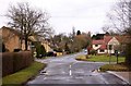
Church Road in Horton-Cum-Studley
Looking up Church Road towards the village green.
Image: © Steve Daniels
Taken: 22 Feb 2010
0.01 miles
2
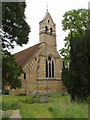
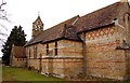
St Barnabas Church, Horton-cum-Studley
Designed in 1867 by William Butterfield. A leaflet in the church says: "One of its most striking features is the colour of the brickwork, which is faded yelow banded with red and dark blue. . . The bricks were hand-made locally."
Image: © David Hawgood
Taken: 1 Jun 2006
0.02 miles
3
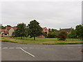
Horton-cum-Studley green
Viewed from the church
Image: © David Hawgood
Taken: 1 Jun 2006
0.02 miles
5
St Barnabas Church at Horton-Cum-Studley
Image: © Steve Daniels
Taken: 22 Feb 2010
0.03 miles
6
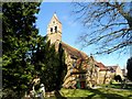
St Barnabas' church, Horton Cum Studley
Built in 1867. The architect was William Butterfield 1814-1900. The use of bricks of different colour is typical of his work.
Image: © Bikeboy
Taken: 22 Mar 2015
0.03 miles
7
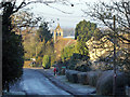
Horton Hill and church, Horton-cum-Studley
St. Barnabas's appears to have two bells.
Image: © Robin Webster
Taken: 4 Dec 2016
0.03 miles
8
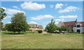
Village Green, Horton-cum-Studley
As the name suggests, this long village is a merger of two formerly separate parishes. This is Horton, at the bottom of the hill, which has always been in Oxfordshire. Studley, at the top of the hill, was once partly in Buckinghamshire and partly in Oxon. The merger of the two villages involved the Counties (Detached Parts) Act of 1844. A full history is on https://en.wikipedia.org/wiki/Horton-cum-Studley
The village is one of the "seven towns of Otmoor" along with the other six villages around the edge of the moor.
Image: © Des Blenkinsopp
Taken: 1 Jun 2020
0.05 miles
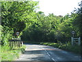
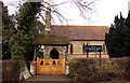
10
Church Lane, Horton-cum-Studley
Church Lane is a no through road heading west out of the village towards various tracks and bridleways. The sign on the verge is showing support for the National Health Service and other key workers during the coronavirus epidemic of 2020.
Image: © Des Blenkinsopp
Taken: 1 Jun 2020
0.10 miles